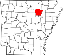
Limedale, Arkansas
Limedale is an unincorporated community in Independence County, Arkansas, in the United States.[1]
It was named for the lime produced there.[2]
References
|
|---|
| | | | Cities | | |
|---|
| | Towns | |
|---|
| Unincorporated
communities |
- Alvis
- Bailey
- Bethesda
- Big Spring Mill, Arkansas
- Bryant
- Cedar Grove (Dota Twp)
- Cedar Grove (Liberty Twp)
- Charlotte
- Clearview Estates
- Collietown
- Cord
- Cushman Junction
- Dennison Heights
- Desha
- Dota
- Dowdy
- Dunnington
- Earnheart
- Elmo
- Floral
- Gaineboro
- Harmontown
- Hazel Grove
- Hickory Valley
- Huff
- Hutchinson
- Jamestown
- Limedale
- Limedale Junction
- Locust Grove
- Maple Springs
- McHue
- Meadow Heights
- Mount Carmel
- Mount Zion
- New Hope
- O'Neal
- Paroquet
- Pattonville
- Pfeiffer
- Pleasant Hill
- Quail Valley
- The Quarry
- Riverview
- Rosie
- Ruddell Hill
- Rutherford
- Salado
- Sandtown
- Sharp
- Simmons
- Southside
- Thida
- Union Hill
- Walnut Grove
- Wrenton
|
|---|
| | Ghost towns |
- Akron
- Blowing Cave
- Denieville
- Departe
- Edmonson
- Limeville
- Lockheart
- Phosphate
- Underwood
|
|---|
| | Footnotes | ‡This populated place also has portions in an adjacent county or counties |
|---|
|
Coordinates: 35°47′38″N 91°43′10″W / 35.79389°N 91.71944°W / 35.79389; -91.71944
