Lime, Oregon
Lime is an unincorporated community in Baker County, Oregon, United States, five miles north of Huntington on U.S. Route 30/Interstate 84.[1] It is near the confluence of Marble Creek and the Burnt River on the Union Pacific Railroad. The Oregon Trail passes through Lime.[2]
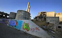
Lime post office was established in 1899 and closed in 1964.[3] In 1940, the community had a population of 18.[4] The deposits of limestone in the area were manufactured into lime that supplied a large area of Eastern Oregon and western Idaho.[3][5] The Acme Cement Plaster Company built a plant at Lime in 1916 to produce plaster.[3] The Sun Portland Cement Company bought the plant in 1921 and built another facility for producing Portland cement.[3] In 1926, the company merged with Oregon Portland Cement Company from Portland; by the 1960s, the Lime facility produced 1,200,000 barrels a year.[3] As the nearby limestone deposits were depleted, limestone was brought from the Nelson area near Durkee.[3] A new plant was built at Nelson in 1979 and the facility at Lime was closed in 1980.[3] Oregon Portland Cement Company merged with the Ash Grove Cement Company in 1983.[3][6]
See also
References
- ↑ "Lime". Geographic Names Information System. United States Geological Survey. November 28, 1980. Retrieved 2010-01-04.
- ↑ Friedman, Ralph (2002) [1993]. The Other Side of Oregon (2nd ed.). Caldwell, Idaho: The Caxton Printers, Ltd. p. 46. ISBN 0-87004-352-8.
- ↑ 3.0 3.1 3.2 3.3 3.4 3.5 3.6 3.7 McArthur, Lewis A.; Lewis L. McArthur (2003) [1928]. Oregon Geographic Names (7th ed.). Portland, Oregon: Oregon Historical Society Press. p. 578. ISBN 0-87595-277-1.
- ↑ Writers' Program of the Work Projects Administration in the State of Oregon (1940). Oregon: End of the Trail. American Guide Series. Portland, Oregon: Binfords & Mort. p. 251. OCLC 4874569.
- ↑ Bailey, Barbara Ruth (1982). Main Street: Northeastern Oregon. Oregon Historical Society. p. 32. ISBN 0-87595-073-6.
- ↑ Merriman, Ed (November 27, 2009). "Durkee doldrums: Locals fear Ash Grove layoffs will doom businesses". Baker City Herald. Retrieved 2010-01-04.
External links
- Images of abandoned cement plant at Lime from Flickr
- Cockle, Richard (April 22, 2012). "Grand Idea to Turn Eastern Oregon Eyesore into Utopia Sparks Skepticism But Also Sliver of Hope". The Oregonian.
| |||||||||||||||||||||

Coordinates: 44°24′24″N 117°18′41″W / 44.40667°N 117.31139°W