Lilhac
| Lilhac | |
|---|---|
|
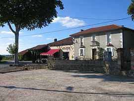
Pétanque courts at the Bon Accord bar | |
 Lilhac | |
|
Location within Midi-Pyrénées region  Lilhac | |
| Coordinates: 43°17′09″N 0°48′36″E / 43.2858°N 0.81°ECoordinates: 43°17′09″N 0°48′36″E / 43.2858°N 0.81°E | |
| Country | France |
| Region | Midi-Pyrénées |
| Department | Haute-Garonne |
| Arrondissement | Saint-Gaudens |
| Canton | Isle-en-Dodon |
| Intercommunality | Portes du Comminges |
| Government | |
| • Mayor (2008–2014) | Gilbert Sioutac |
| Area1 | 7.3 km2 (2.8 sq mi) |
| Population (2008)2 | 134 |
| • Density | 18/km2 (48/sq mi) |
| INSEE/Postal code | 31301 / 31230 |
| Elevation |
280–381 m (919–1,250 ft) (avg. 390 m or 1,280 ft) |
|
1 French Land Register data, which excludes lakes, ponds, glaciers > 1 km² (0.386 sq mi or 247 acres) and river estuaries. 2 Population without double counting: residents of multiple communes (e.g., students and military personnel) only counted once. | |
Lilhac is a commune in the Haute Garonne department in southwestern France.
Population
| Historical population | ||
|---|---|---|
| Year | Pop. | ±% |
| 1962 | 124 | — |
| 1968 | 143 | +15.3% |
| 1975 | 120 | −16.1% |
| 1982 | 133 | +10.8% |
| 1990 | 111 | −16.5% |
| 1999 | 90 | −18.9% |
| 2008 | 134 | +48.9% |
Local inhabitants are called Lilhacais.
Geography
Lilhac lies roughly 65 km southwest from Toulouse. Its altitude at the highest point is 380 metres, and covers an area of 730ha or 7.3 km².
The Touch River has its source in the commune.
History
Lilhac was registered as a commune in 1668. The local church, Eglise St-Quitterie, dedicated to Saint Quiteria, dates to before the 18th century.
See also
- Communes of the Haute-Garonne department
References
| Wikimedia Commons has media related to Lilhac. |