Lifta
| Lifta | |
|---|---|
|
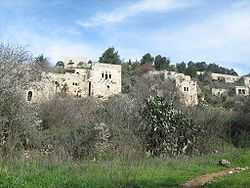
Depopulated homes on the hillside | |
 Lifta | |
| Arabic | لفتا |
| Name meaning | Lifta, personal name[1] |
| Also spelled | Lefta |
| Subdistrict | Jerusalem |
| Coordinates | 31°47′43″N 35°11′47″E / 31.79528°N 35.19639°ECoordinates: 31°47′43″N 35°11′47″E / 31.79528°N 35.19639°E |
| Palestine grid | 168/133 |
| Population | 2,958 (1948[2]) |
| Area |
8,743 dunams 8.7 km² |
| Date of depopulation | January 1948[3] |
| Cause(s) of depopulation | Military assault by Yishuv forces |
| Current localities | Western suburb of Jerusalem |
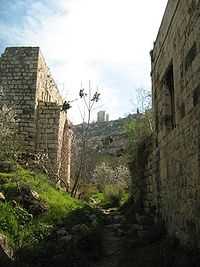

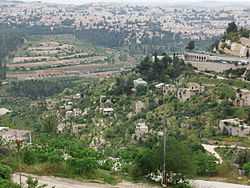
Lifta (Arabic: لفتا; Hebrew: מי נפתוח Mei Niftoach, lit. spring of the corridor) was a Palestinian Arab village on the outskirts of Jerusalem. The population was driven out during the Arab-Jewish hostilities of 1947/48 and the efforts to relieve the Siege of Jerusalem (1948). The village, which is mainly intact, is located on a hillside between the western entrance to Jerusalem and the Romema neighbourhood. In 2012, plans to rebuild the village as an upscale neighborhood were rejected by the Jerusalem District Court.[4]
History
The site has been populated since ancient times; Nephtoah (Hebrew: נפתח) is mentioned in the Hebrew Bible as a border between the Israelite tribes of Judah and Benjamin. It was the northernmost demarcation point of the territory of the Tribe of Judah.[5][6] The Romans and Byzantines called it Nephtho, and the Crusaders referred to it as Clepsta.[7]
Ottoman era
In 1596, Lifta was a village in the Ottoman Empire, nahiya (subdistrict) of Jerusalem under the liwa' (district) of Jerusalem, and it had a population of 396. It paid taxes on wheat, barley, olives, fruit orchards and vineyards.[8] In 1834, the Egyptian Ibrahim Pasha and his army fought and defeated local rebels, led by al-Shaykh Qasim al-Ahmad, a prominent local ruler. However, the Qasim al-Ahmad family remained powerful and ruled the region southwest of Nablus from their fortified villages of Deir Istiya and Bayt Wazan some 40 kilometers (25 mi) due north of Lifta.[9] In the late nineteenth century, Lifta was described as a village on the side of a steep hill, with a spring and rock-cut tombs to the south.[10]
British Mandate era
In 1917, Lifta surrendered to the British forces with white flags and, as a symbolic gesture, the keys to the village.[11]
In mid-1940, Lifta was predominantly Muslim, with a population of 2,550. The village had a mosque, a shrine for Shaykh Badr (a local sage), two coffee houses, a social club, and a few shops. It also had an elementary school, one for boys and one for girls. The farmers of Lifta marketed their produce in Jerusalem markets and took advantage of the city's services.[12]
1948, and after
In the 1948 war, one of the goals of the Haganah was securing the western exit of the city. Towards this end, Arabs fled from villages at the entrance to Jerusalem, among them Lifta. In 1947, the Haganah shot a Lifta resident who informed Arab forces about the departure of Jewish convoys to Tel Aviv.[12] According to historian 'Arif al-'Arif, a coffeehouse in Lifta was attacked by members of the Stern Gang, killing six and wounding seven.[12] After the attack, most of the inhabitants fled, but the village remained largely intact. Some 55 original stone houses are still standing but the village has never been repopulated.[13]
In 2011, plans were announced to demolish the village and build a luxury development consisting of 212 luxury housing units and a hotel.[14] Former residents brought a legal petition to preserve the village as a historic site.[15] Lifta is the last remaining Arab village that was depopulated to have not been either completely destroyed or re-inhabited.[14]
Culture
Lifta was known to be among the wealthiest communities in the Jerusalem area, and their embroiderers were reported to be among the most artistic.[16] Thob Ghabani bridal dresses were very popular in Lifta and in Malha. These dresses were made of ghabani, a natural cotton covered with gold color silk floral embroidery produced in Aleppo, and were much more narrow than other dresses and with sleeves which were not as wide as normal. The sides, sleeves and chest panel of the dress were all adorned with silk insets. These dresses were normally ordered from Bethlehem by the future bride.[17] The married women of Lifta used the distinctive conical shaṭweh head-dress , embellished with their bride-money. Beside being used in Bethlehem, it was only used in Lifta, Ain Karm, Beit Jala and Beit Sahur.[18]
See also
- Ali Abunimah
- Rasmea Odeh
- Yahya_Hammuda
- List of Arab towns and villages depopulated during the 1948 Arab-Israeli War
- Palestinian costumes
- Zochrot
References
- ↑ Palmer, 1881, p. 322
- ↑ Palestinian Central Bureau of Statistics also gives village area
- ↑ Morris, 2006, p. xviii, town #363.
- ↑ Court rules against demolition of empty Lifta homes
- ↑ MikraNet
- ↑ Nephtoah Bible Dictionary
- ↑ Heritage conservation in Israel: Lifta
- ↑ Hütteroth and Abdulfattah, 1977, p. 115. Quoted in Khalidi, 1992, p. 301
- ↑ Khalidi, 1992, p. 301
- ↑ Conder and Kitchener, 1883, III:18. Quoted in Khalidi, 1992, p.301
- ↑ Gilbert, 1936, 157-168
- ↑ 12.0 12.1 12.2 Rami Nashashibi (June 1996). "Litfa". Destroyed Palestinian Villages. Center for Research and Documentation of Palestinian Society, Birzeit University. Archived from the original on 2003-07-19. Retrieved 2011-05-30.
- ↑ Unofficial monument to a decisive time in history, Esther Zandberg, Nov. 25, 2004, Haaretz
- ↑ 14.0 14.1 Israel moves to turn deserted Palestinian village into luxury housing project Haaretz, 21 January 2011
- ↑ Knell, Yolande (30 May 2011). "Legal battle over an abandoned Palestinian village". BBC. Retrieved 30 May 2011.
- ↑ Woven legacy, woven language Saudi Aramco World, Volume 42, Number 1
- ↑ Stillman, 1979, p. 42, 44 (ill.)
- ↑ Stillman, 1979, p. 37
Bibliography
| Wikimedia Commons has media related to Lifta. |
- Avner, Rina (2008-01-18), Jerusalem, Lifta Final Report (120), Hadashot Arkheologiyot – Excavations and Surveys in Israel
- Barclay, James Turner (1858). The city of Great King; or, Jerusalem as it was. Philadelphia: J. Challen and sons [etc.] (p. 544 )
- Barron, J. B., ed. (1923). Palestine: Report and General Abstracts of the Census of 1922. Government of Palestine.
- Conder, Claude Reignier; Kitchener, H. H. (1883). The Survey of Western Palestine: Memoirs of the Topography, Orography, Hydrography, and Archaeology 3. London: Committee of the Palestine Exploration Fund.
- Dagan, Yehuda; Barda, Leticia (2010-12-26), Jerusalem, Lift Survey Final Report (122), Hadashot Arkheologiyot – Excavations and Surveys in Israel
- Dauphin, Claudine (1998). La Palestine byzantine, Peuplement et Populations. BAR International Series 726 (in French). III : Catalogue. Oxford: Archeopress. (p. 900)
- Gilbert, Major Vivian (1936): The Romance of the last Crusade, London,
- Guérin, Victor (1868). Description Géographique Historique et Archéologique de la Palestine (in French). 1: Judee, pt. 1. Paris: L'Imprimerie Nationale. 29 April 1863 (Guérin, 1868, pp. 252-256 )
- Hadawi, Sami (1970). Village Statistics of 1945: A Classification of Land and Area ownership in Palestine. Palestine Liberation Organization Research Center.
- Haiman, Mordechai (2011-09-19), Jerusalem, Lifta Final Report (123), Hadashot Arkheologiyot – Excavations and Surveys in Israel
- Hütteroth, Wolf-Dieter; Abdulfattah, Kamal (1977). Historical Geography of Palestine, Transjordan and Southern Syria in the Late 16th Century. Erlanger Geographische Arbeiten, Sonderband 5. Erlangen, Germany: Vorstand der Fränkischen Geographischen Gesellschaft. ISBN 3-920405-41-2.
- Khalidi, Walid (1992). All That Remains: The Palestinian Villages Occupied and Depopulated by Israel in 1948. Washington D.C.: Institute for Palestine Studies. ISBN 0-88728-224-5.
- Mills, E., ed. (1932). Census of Palestine 1931. Population of Villages, Towns and Administrative Areas. Jerusalem: Government of Palestine.
- Morris, Benny (2004). The Birth of the Palestinian Refugee Problem Revisited. Cambridge University Press. ISBN 0-521-00967-7.
- Palmer, E. H. (1881). The Survey of Western Palestine: Arabic and English Name Lists Collected During the Survey by Lieutenants Conder and Kitchener, R. E. Transliterated and Explained by E.H. Palmer. Committee of the Palestine Exploration Fund.
- Pringle, Denys (1997). Secular buildings in the Crusader Kingdom of Jerusalem: an archaeological Gazetter. Cambridge University Press. ISBN 0521 46010 7. (p. 66)
- Schölch, Alexander (1993). Palestine in Transformation, 1856-1882: Studies in Social, Economic, and Political Development. Institute for Palestine Studies. ISBN 978-0-88728-234-8.
- Stillman, Yedida Kalfol (1979): Palestinian Costume and Jewelry, ISBN 0-8263-0490-7
- Socin, A. (1879). "Alphabetisches Verzeichniss von Ortschaften des Paschalik Jerusalem". Zeitschrift des Deutschen Palästina-Vereins 2: 135–163. (p. 157 )
- Tobler, Titus (1854). Dr. Titus Toblers zwei Bucher Topographie von Jerusalem und seinen Umgebungen (in German) 2. Berlin: G. Reimer. (pp. 758-760; cited in Pringle, 1997, p. 66)
- Zelinger, Yehiel (2011-09-18), Jerusalem, Lifta, Final Report (123), Hadashot Arkheologiyot – Excavations and Surveys in Israel
External links
- Welcome to Lifta
- SWP map XVII, IAA
- SWP map 17, Wikimedia commons
- F.A.S.T. - Lifta Preservation Joint project on the reconstruction of memory and the preservation of Lifta May 14, 2006
- Lifta Photos, from Dr. Moslih Kanaaneh
- Lifta, by Rami Nashashibi (1996), Center for Research and Documentation of Palestinian Society.
- Lifta, Zochrot
- Return to Lifta, May 13, 2006, Zochrot
- Lifta Society Website
- Litfa Website
- 3D models of different houses in Lifta