Lierne
| Lierne kommune | |||
|---|---|---|---|
| Municipality | |||
| |||
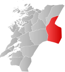
 Lierne within Nord-Trøndelag | |||
| Coordinates: 64°22′34″N 13°36′35″E / 64.37611°N 13.60972°ECoordinates: 64°22′34″N 13°36′35″E / 64.37611°N 13.60972°E | |||
| Country | Norway | ||
| County | Nord-Trøndelag | ||
| District | Namdalen | ||
| Administrative centre | Sandvika | ||
| Government | |||
| • Mayor (2007) | Alf Robert Arvasli (Ap) | ||
| Area | |||
| • Total | 2,961.71 km2 (1,143.52 sq mi) | ||
| • Land | 2,631.23 km2 (1,015.92 sq mi) | ||
| • Water | 330.48 km2 (127.60 sq mi) | ||
| Area rank | 14 in Norway | ||
| Population (2011) | |||
| • Total | 1,406 | ||
| • Rank | 367 in Norway | ||
| • Density | 0.5/km2 (1/sq mi) | ||
| • Change (10 years) | -10.1 % | ||
| Demonym | Libygg[1] | ||
| Time zone | CET (UTC+1) | ||
| • Summer (DST) | CEST (UTC+2) | ||
| ISO 3166 code | NO-1738 | ||
| Official language form | Neutral | ||
| Website |
www | ||
|
| |||
Lierne is a municipality in Nord-Trøndelag county, Norway. It is part of the Namdalen region, and it is the largest municipality in Trøndelag. The administrative centre of the municipality is the village of Sandvika. Other villages include Inderdal, Sørli, and Tunnsjø senter. The municipality borders Sweden to the south and east.[2]

The cross-country race Flyktningerennet is held here every year. It is a race that follows a route from Nordli to Gäddede in Strömsund Municipality, Sweden, in remembrance of the people who fled Nazi German-occupied Norway for Sweden during the Second World War.
General information
The municipality of Lierne was established on 1 January 1874 when it was separated from Snåsa. Initially, the population of Lierne was 1,015. On 1 July 1915, it was divided into two municipalities: Nordli (population: 863) and Sørli (population: 739). This division, however, was short-lived. On 1 January 1964 they were merged back together again under the former name Lierne. After the merger, there were 2,045 residents in the new municipality.[3]
Name
The Old Norse form of the name was Finnahlíð, where the first element is the plural genitive case of finnr which means "Sami person" (because the district was mostly populated by Sami people at the time). The later form Lierne is the definite plural form of li (Old Norse hlíð) which means "mountainside".
Coat-of-arms
The coat-of-arms is from modern times; they were granted on 3 February 1984. The arms show three white Willow Ptarmigans (Lagopus lagopus) on a blue background. The birds are plentiful in the area and hunting them was of great importance historically for the inhabitants to survive during the winters in the area. The bird was thus chosen as a symbol for the municipality.[4]
Churches
The Church of Norway has two parishes (sokn) within the municipality of Lierne. It is part of the Namdal deanery in the Diocese of Nidaros.
| Parish (Sokn) | Church Name | Location of the Church | Year Built |
|---|---|---|---|
| Nordli | Nordli Church | Sandvika | 1873 |
| Tunnsjø Chapel | Tunnsjø senter | 1876 | |
| Sørli | Sørli Church | Sørli | 1873 |
Geography
Lierne National Park is located in the municipality, and Blåfjella-Skjækerfjella National Park is partly located in Lierne. Lierne has a significant population of brown bears.
Lierne is also home to many lakes, including Gusvatnet, Havdalsvatnet, Holden, Ingelsvatnet, Kingen, Kvesjøen, Laksjøen, Lenglingen, Limingen, Murusjøen, Rengen, Sandsjøen, Stortissvatnet, Tunnsjøen, and Ulen.
References
- ↑ "Personnemningar til stadnamn i Noreg" (in Norwegian). Språkrådet.
- ↑ Store norske leksikon. "Lierne" (in Norwegian). Retrieved 2011-09-10.
- ↑ Jukvam, Dag (1999). "Historisk oversikt over endringer i kommune- og fylkesinndelingen" (in Norwegian). Statistisk sentralbyrå.
- ↑ Norske Kommunevåpen (1990). "Nye kommunevåbener i Norden". Retrieved 8 November 2008.
External links
| Wikimedia Commons has media related to Lierne. |
 Nord-Trøndelag travel guide from Wikivoyage
- Municipal fact sheet from Statistics Norway
| ||||||||||||


