Licodia Eubea
| Licodia Eubea | ||
|---|---|---|
| Comune | ||
| Comune di Licodia Eubea | ||
|
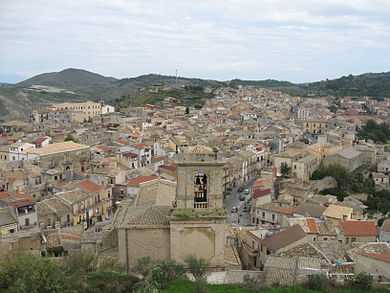
View of Licodia Eubea. | ||
| ||
 Licodia Eubea Location of Licodia Eubea in Italy | ||
| Coordinates: 37°09′N 14°42′E / 37.150°N 14.700°E | ||
| Country | Italy | |
| Region | Sicily | |
| Province | Catania (CT) | |
| Government | ||
| • Mayor | Giovanni Verga | |
| Area | ||
| • Total | 111 km2 (43 sq mi) | |
| Elevation | 688 m (2,257 ft) | |
| Population (March 2009) | ||
| • Total | 3,162 | |
| • Density | 28/km2 (74/sq mi) | |
| Demonym | Licodiani | |
| Time zone | CET (UTC+1) | |
| • Summer (DST) | CEST (UTC+2) | |
| Postal code | 95040 | |
| Dialing code | 0933 | |
| Patron saint | St. Margaret | |
| Saint day | July 20 | |
| Website | Official website | |
Licodia Eubea (Sicilian: Licuddìa) is a town and comune in the province of Catania, on the island of Sicily. It is bounded by the comuni of Caltagirone, Chiaramonte Gulfi, Giarratana, Grammichele, Mazzarrone, Mineo, Monterosso Almo and Vizzini. It rises over an internal hilly area, 630 metres (2,070 ft) above sea level.
Situated above a hill overlooking the valley of the Dirillo river, Licodia Eubea boasts a rich production of olives, almonds, citrus fruits, and excellent table grapes, that can be tasted during the annual Sagra dell'Uva (Grapes' festival) held in the month of September. Cattle breeding, as well as horse, sheep, and goat farms, are flourishing, not to mention the production of absolutely delicious typical Sicilian cheeses.
Beautiful to visit are the Chiesa Madre dedicated to S. Margherita, erected during the 17th century, preserving the emblem of the Santapau family on its front portal, the Chiesa del Rosario of the 18th century, and the Palazzo Municipale (Town Hall building).

History
The name Licodia derives from the Greek word 'Licos' meaning wolf, which is why its Coat-of-Arms has a picture of a wolf. The suburb belonged to lord Riccardo Filangieri, and was afterwards bestowed to nobleman Manfredi Aragona.
The name Eubea was given to the place in 1872, to identify with the Greek city of Eubea, the colony of Leontini, founded early in the 6th century BC on the same site of an unknown Sicel settlement. Vases of the First Period were found and all the tombs explored in 1898 belonged to the Fourth Period (700–500 BCE), and show the gradual process of Hellenization among the Sicels.
In 1392, the ancient castle was bestowed to the Santapau family, that gave it its name and owned it until the 16th century, when it passed under the dominion of lord Vincenzo Ruffo. In 1693, the town was devastated by the earthquake, and experienced a slow reconstruction.
Twin towns
External links
- Official website (Italian)
![]() This article incorporates text from a publication now in the public domain: Chisholm, Hugh, ed. (1911). Encyclopædia Britannica (11th ed.). Cambridge University Press.
This article incorporates text from a publication now in the public domain: Chisholm, Hugh, ed. (1911). Encyclopædia Britannica (11th ed.). Cambridge University Press.

