Licciana Nardi
| Licciana Nardi | |
|---|---|
| Comune | |
| Comune di Licciana Nardi | |
|
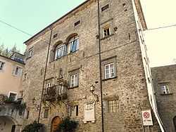
The castle of Licciana. | |
 Licciana Nardi Location of Licciana Nardi in Italy | |
| Coordinates: 44°16′N 10°2′E / 44.267°N 10.033°ECoordinates: 44°16′N 10°2′E / 44.267°N 10.033°E | |
| Country | Italy |
| Region | Tuscany |
| Province | Massa and Carrara (MS) |
| Frazioni | Monti, Amola, Apella, Bastia, Cisigliana, Costamala, Panicale, Paretola, Pontebosio, Tavernelle, Taponecco, Terrarossa, Varano, Villa. |
| Area | |
| • Total | 55 km2 (21 sq mi) |
| Elevation | 210 m (690 ft) |
| Population (31 May 2007)[1] | |
| • Total | 4,977 |
| • Density | 90/km2 (230/sq mi) |
| Demonym | Liccianesi |
| Time zone | CET (UTC+1) |
| • Summer (DST) | CEST (UTC+2) |
| Postal code | 54016 |
| Dialing code | 0187 |
| Patron saint | Saint James the Greater |
| Saint day | 25 July |
| Website | Official website |
Licciana Nardi is a comune (municipality) in the Province of Massa and Carrara in the Italian region Tuscany, located about 110 kilometres (68 mi) northwest of Florence and about 25 kilometres (16 mi) northwest of Massa.
Geography
The town lies in the Lunigiana region on the border between Tuscany and Liguria, with the Apuane Alps as a backdrop. It is only a few kilometres from Massa and La Spezia and near famous tourist spots as Lerici, Portovenere and the Cinque Terre.
Licciana Nardi borders the following municipalities: Aulla, Bagnone, Comano, Fivizzano, Monchio delle Corti, Podenzana, Tresana, Villafranca in Lunigiana.
History
In 1933, Licciana was surnamed Nardi in honour of Italian patriot Anacarsi Nardi (1800–1844).
Twin towns
-
 Somerton, Somerset, United Kingdom
 -
 Romagnat, Auvergne, France
Villages
Tavenelle is a small village in the hills of the Lunigiana, at 450 metres (1,480 ft) above sea level. It has a medieval centre with a restaurant, bar, and campsite.
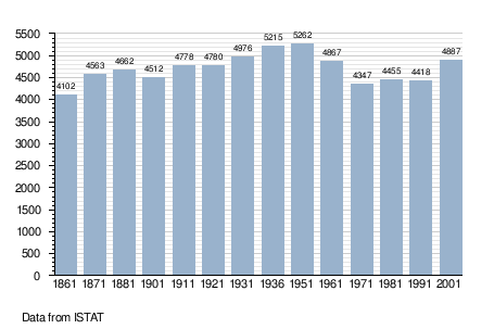
Demographic evolution
References
| Wikimedia Commons has media related to Licciana Nardi. |