Liberty Center, Ohio
| Liberty Center, Ohio | |
|---|---|
| Village | |
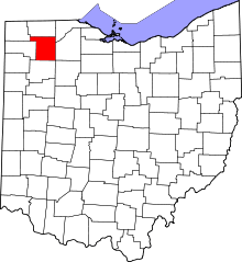
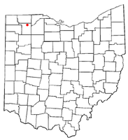 Location of Liberty Center, Ohio | |
| Coordinates: 41°26′38″N 84°0′30″W / 41.44389°N 84.00833°WCoordinates: 41°26′38″N 84°0′30″W / 41.44389°N 84.00833°W | |
| Country | United States |
| State | Ohio |
| County | Henry |
| Government | |
| • Mayor | Max Fetterman |
| Area[1] | |
| • Total | 1.04 sq mi (2.69 km2) |
| • Land | 1.04 sq mi (2.69 km2) |
| • Water | 0 sq mi (0 km2) |
| Elevation[2] | 679 ft (207 m) |
| Population (2010)[3] | |
| • Total | 1,180 |
| • Estimate (2012[4]) | 1,169 |
| • Density | 1,134.6/sq mi (438.1/km2) |
| Time zone | Eastern (EST) (UTC-5) |
| • Summer (DST) | EDT (UTC-4) |
| ZIP code | 43532 |
| Area code(s) | 419 |
| FIPS code | 39-43414[5] |
| GNIS feature ID | 1064993[2] |
| Website |
libertycentervillage |
Liberty Center is a village in Henry County, Ohio, United States. The population was 1,180 at the United States Census 2010.
Geography
Liberty Center is located at 41°26′38″N 84°0′30″W / 41.44389°N 84.00833°W (41.443937, -84.008343).[6]
According to the United States Census Bureau, the village has a total area of 1.04 square miles (2.69 km2), all land.[1]
Demographics
The median income for a household in the village was $40,395, and the median income for a family was $46,302. Males had a median income of $35,848 versus $21,597 for females. The per capita income for the village was $19,966. About 3.9% of families and 6.7% of the population were below the poverty line, including 10.4% of those under age 18 and 4.1% of those age 65 or over.
2010 census
As of the census[3] of 2010, there were 1,180 people, 446 households, and 316 families residing in the village. The population density was 1,134.6 inhabitants per square mile (438.1/km2). There were 485 housing units at an average density of 466.3 per square mile (180.0/km2). The racial makeup of the village was 98.2% White, 0.1% African American, 0.1% Native American, 0.2% Asian, 0.3% from other races, and 1.2% from two or more races. Hispanic or Latino of any race were 3.3% of the population.
There were 446 households of which 39.0% had children under the age of 18 living with them, 52.0% were married couples living together, 11.4% had a female householder with no husband present, 7.4% had a male householder with no wife present, and 29.1% were non-families. 26.2% of all households were made up of individuals and 10.3% had someone living alone who was 65 years of age or older. The average household size was 2.65 and the average family size was 3.17.
The median age in the village was 33.9 years. 30.7% of residents were under the age of 18; 8.3% were between the ages of 18 and 24; 26% were from 25 to 44; 24.6% were from 45 to 64; and 10.7% were 65 years of age or older. The gender makeup of the village was 49.3% male and 50.7% female.
References
- ↑ 1.0 1.1 "US Gazetteer files 2010". United States Census Bureau. Retrieved 2013-01-06.
- ↑ 2.0 2.1 "US Board on Geographic Names". United States Geological Survey. 2007-10-25. Retrieved 2008-01-31.
- ↑ 3.0 3.1 "American FactFinder". United States Census Bureau. Retrieved 2013-01-06.
- ↑ "Population Estimates". United States Census Bureau. Retrieved 2013-06-17.
- ↑ "American FactFinder". United States Census Bureau. Retrieved 2008-01-31.
- ↑ "US Gazetteer files: 2010, 2000, and 1990". United States Census Bureau. 2011-02-12. Retrieved 2011-04-23.
External links
- Liberty Center Village website
- Liberty Center Local School District Home Page
- Liberty Center Public Library Home Page
- Pictures of Several Liberty Center Cemeteries
| |||||||||||||||||||||||||||||