Lewis Range
| Lewis Range | |
|---|---|
|
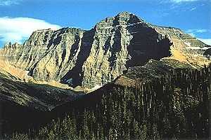
Mount Cleveland is the highest peak in the Lewis Range | |
| Highest point | |
| Peak | Mount Cleveland |
| Elevation | 10,466 ft (3,190 m) |
| Coordinates | 48°55′29″N 113°50′53″W / 48.92472°N 113.84806°WCoordinates: 48°55′29″N 113°50′53″W / 48.92472°N 113.84806°W |
| Geography | |
|
<div style="padding:2px 2px 2px 2px;> 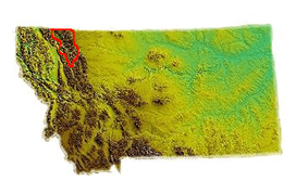 | |
| Countries | United States and Canada |
| States/Provinces | Montana and Alberta |
| Parent range | Rocky Mountains |
| Geology | |
| Orogeny | Lewis Overthrust |
The Lewis Range is a mountain range located in the Rocky Mountains of northern Montana, U.S. and extreme southern Alberta, Canada. Formed by the Lewis Overthrust beginning 170 million years ago, an enormous slab of Precambrian rocks 3 miles (4.8 km) thick, 50 miles (80 km) wide and 160 miles (260 km) long faulted and slid over newer rocks of the Cretaceous period. In this relatively rare occurrence, older rocks are now positioned above newer ones.
The Lewis Range is within Waterton Lakes National Park in Canada, and in Glacier National Park and the Bob Marshall Wilderness Complex located in Flathead and Lewis and Clark National Forests in Montana. The Continental Divide spans much of the uppermost sections of the range. Major peaks in the range include Mount Cleveland (10,466 ft/3,185 m), which is the highest peak in the range and in Glacier National Park. Other prominent peaks include Mount Stimson (10,142 ft/3,091 m), Mount Jackson (10,052 ft/3,064 m), Mount Siyeh (10,014 ft/3,052 m), Going to the Sun Mountain, (9,642 ft/2,939 m) and the isolated Chief Mountain (9,080 ft/2,768 m). The Chinese wall in the Bob Marshall Wilderness is a 1,000 foot (304 m) high feature that runs for 40 miles (64 km). Major passes include Marias Pass and Logan Pass which bisects Glacier National Park east to west.
See also
- Mountains and mountain ranges of Glacier National Park (U.S.)
- List of mountain ranges in Montana
External links
- Glacier National Park. "Lewis Overthrust Fault". Geology. Retrieved 2006-05-08.
| Wikimedia Commons has media related to Lewis Range. |