Lewis Overthrust
Coordinates: 48°55′58″N 113°36′33″W / 48.93278°N 113.60917°W
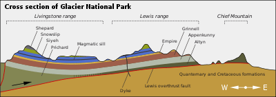
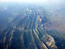
The Lewis Overthrust is a geologic thrust fault structure of the Rocky Mountains within Glacier National Park in Montana, USA and Waterton Lakes National Park in Alberta, Canada, as well as into Lewis and Clark National Forest. It provides scientific insight into geologic processes happening in other parts of the world, like the Andes and the Himalaya Mountains. Scientific study of this region is practical because the original rock characteristics were well-preserved and recently sculptured by glaciers. The Lewis and Livingston mountain ranges are the visible reminders of this fault. The Rocky Mountain Front is the easternmost portion of the Lewis Range which rises abruptly 4,000 to 5,000 feet (1,200 to 1,500 m) above the Great Plains.
The Lewis Overthrust started during the formation of the Rocky Mountains 170 million years ago as a result of colliding tectonic plates. Stresses on the continental plates pushed a huge rock wedge eastward more than 50 miles (80 km). The rock wedge, which was several miles thick and several hundred miles long, consisted of Proterozoic rock formations. The underlying layer consisted of softer, Cretaceous age rocks that were over 1,400 million years younger than the overthrust layer.
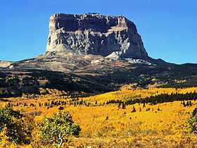
Chief Mountain is a highly visible example of the Lewis Overthrust. The mountain is an isolated remnant (a klippe) of the eastern edge of the upper plate. Erosion over time has shaped the mountain into its characteristic shape, where it towers over the prairie.
References
- "Geology Fieldnotes: Glacier National Park, Montana". National Park Service Nature & Science. Retrieved 2006-04-25.