Lesidren Island
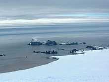 Zed Islands (in the background) from Miziya Peak; Lesidren Island is the second on the right. | |
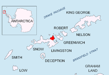 Location of Varna Peninsula on Livingston Island in the South Shetland Islands. | |
| Geography | |
|---|---|
| Location | Antarctica |
| Coordinates | 62°26′10″S 60°08′55″W / 62.43611°S 60.14861°W |
| Archipelago | Zed Islands |
| Area | 33 ha (82 acres) |
| Length | 0.8 km (0.5 mi) |
| Width | 0.6 km (0.37 mi) |
| Country | |
| Demographics | |
| Population | 0 |
| Additional information | |
| Administered under the Antarctic Treaty System | |

Lesidren Island (Bulgarian: остров Лесидрен, ‘Ostrov Lesidren’ 'os-trov 'le-si-dren) is the second largest and southernmost island in the Zed group off the north coast of Varna Peninsula, Livingston Island in the South Shetland Islands, Antarctica. The island is ice-free, extending 800 by 600 m (870 by 660 yd) with surface area 33 hectares (82 acres).[1] Separated from the neighbouring Phanagoria Island and Koshava Island by channels 130 and 140 m (140 and 150 yd) wide respectively. The area was visited by early 19th century sealers.
The island is named after the settlement of Lesidren in northern Bulgaria.
Location
Lesidren Island is located at 62°26′10″S 60°08′55″W / 62.43611°S 60.14861°W which is 1.53 km (0.95 mi) north of Williams Point on Livingston Island. British mapping in 1968, Chilean in 1971, Argentine in 1980, Bulgarian in 2005 and 2009.
See also
- Composite Gazetteer of Antarctica
- List of Antarctic islands south of 60° S
- SCAR
- Territorial claims in Antarctica
References
- ↑ L.L. Ivanov. Antarctica: Livingston Island and Greenwich, Robert, Snow and Smith Islands. Scale 1:120000 topographic map. Troyan: Manfred Wörner Foundation, 2009. ISBN 978-954-92032-6-4
- Bulgarian Antarctic Gazetteer. Antarctic Place-names Commission. (details in Bulgarian, basic data in English)
External links
- Lesidren Island. SCAR Composite Antarctic Gazetteer.
This article includes information from the Antarctic Place-names Commission of Bulgaria which is used with permission.