Les Escaldes
| Les Escaldes | |
|---|---|
|
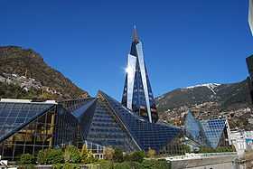
Caldea thermal spa and wellness resort | |
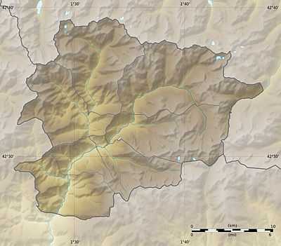 Les Escaldes Location in Andorra | |
| Coordinates: 42°30′N 1°32′E / 42.500°N 1.533°E | |
| Country |
|
| Parish | Escaldes-Engordany |
| Elevation | 1,053 m (3,455 ft) |
Les Escaldes (Catalan pronunciation: [ɫəz əsˈkaɫdəs], locally: [lez asˈkaɫdes]) or briefly Escaldes is an urban area in Escaldes-Engordany parish, Andorra. It is located near the nation's capital, Andorra la Vella.
Overview
The name Les Escaldes comes from the presence of numerous hot springs, which produce highly sulphurous and nitrogenous waters at temperatures between 22 °C and 66 °C.[1] The hot springs were known by the Romans who used them for medical purposes.[1]
There was a textile industry from the Middle Ages, producing woven fabrics and umbrellas in several guilds. The area is also known for its traditional dance, the Santa Anna.[1]
Climate
| Climate data for Les Escaldes | |||||||||||||
|---|---|---|---|---|---|---|---|---|---|---|---|---|---|
| Month | Jan | Feb | Mar | Apr | May | Jun | Jul | Aug | Sep | Oct | Nov | Dec | Year |
| Record high °C (°F) | 15 (59) |
17 (63) |
20 (68) |
25 (77) |
29 (84) |
36 (97) |
35 (95) |
33 (91) |
31 (88) |
27 (81) |
20 (68) |
13 (55) |
36 (97) |
| Average high °C (°F) | 6 (43) |
7 (45) |
12 (54) |
14 (57) |
17 (63) |
23 (73) |
26 (79) |
24 (75) |
22 (72) |
16 (61) |
10 (50) |
6 (43) |
15.3 (59.5) |
| Average low °C (°F) | −1 (30) |
−1 (30) |
2 (36) |
4 (39) |
6 (43) |
10 (50) |
12 (54) |
12 (54) |
10 (50) |
6 (43) |
2 (36) |
−1 (30) |
5.1 (41.2) |
| Record low °C (°F) | −13 (9) |
−18 (0) |
−9 (16) |
−4 (25) |
0 (32) |
2 (36) |
5 (41) |
4 (39) |
2 (36) |
−5 (23) |
−5 (23) |
−11 (12) |
−18 (0) |
| Average precipitation mm (inches) | 34 (1.34) |
37 (1.46) |
46 (1.81) |
63 (2.48) |
105 (4.13) |
69 (2.72) |
65 (2.56) |
98 (3.86) |
81 (3.19) |
73 (2.87) |
68 (2.68) |
69 (2.72) |
808 (31.81) |
| Source: BBC Weather [2] | |||||||||||||
References
- ↑ 1.0 1.1 1.2 Les Escaldes, Enciclopèdia Catalana. (Catalan)
- ↑ "Average Conditions Les Escaldes, Andorra". BBC Weather. Retrieved July 17, 2010.
External links
![]() Media related to Escaldes-Engordany at Wikimedia Commons
Media related to Escaldes-Engordany at Wikimedia Commons
| |||||||||||||||||||||||||||||||||||||