Les Chères
| Les Chères | ||
|---|---|---|
|
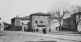
A view within Les Chères, at the beginning of the 20th century | ||
| ||
 Les Chères | ||
|
Location within Rhône-Alpes region  Les Chères | ||
| Coordinates: 45°53′25″N 4°44′36″E / 45.8903°N 4.7433°ECoordinates: 45°53′25″N 4°44′36″E / 45.8903°N 4.7433°E | ||
| Country | France | |
| Region | Rhône-Alpes | |
| Department | Rhône | |
| Arrondissement | Villefranche-sur-Saône | |
| Canton | Anse | |
| Government | ||
| • Mayor (2008–2014) | Marie-Laure Bonnefoy | |
| Area1 | 5.46 km2 (2.11 sq mi) | |
| Population (2007)2 | 1,235 | |
| • Density | 230/km2 (590/sq mi) | |
| INSEE/Postal code | 69055 / 69380 | |
| Elevation |
176–212 m (577–696 ft) (avg. 210 m or 690 ft) | |
|
1 French Land Register data, which excludes lakes, ponds, glaciers > 1 km² (0.386 sq mi or 247 acres) and river estuaries. 2 Population without double counting: residents of multiple communes (e.g., students and military personnel) only counted once. | ||
.svg.png)
Les Chères is a commune in the Rhône department in eastern France.
See also
Communes of the Rhône department
References
| Wikimedia Commons has media related to Les Chères. |