Leroy Township, Barton County, Missouri
| Leroy Township | |
|---|---|
| Township | |
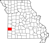
 Location in Barton County | |
| Coordinates: 37°37′05″N 094°31′51″W / 37.61806°N 94.53083°WCoordinates: 37°37′05″N 094°31′51″W / 37.61806°N 94.53083°W | |
| Country | United States |
| State | Missouri |
| County | Barton |
| Area | |
| • Total | 40.44 sq mi (104.74 km2) |
| • Land | 40.14 sq mi (103.95 km2) |
| • Water | 0.31 sq mi (0.79 km2) 0.75% |
| Elevation | 843 ft (257 m) |
| Population (2000) | |
| • Total | 238 |
| • Density | 5.9/sq mi (2.3/km2) |
| GNIS feature ID | 0766280 |
Leroy Township is a township in Barton County, Missouri, USA. As of the 2000 census, its population was 238.
Geography
Leroy Township covers an area of 40.44 square miles (104.7 km2) and contains no incorporated settlements. According to the USGS, it contains two cemeteries: Leroy and Shiloh.
The streams of Bitter Creek, East Fork Dry Wood Creek and West Elm Branch run through this township.
References
External links
| |||||||||||||||||||||||||||||