Leni
| Leni | |
|---|---|
| Comune | |
| Comune di Leni | |
 Leni Location of Leni in Italy | |
| Coordinates: 38°33′N 14°50′E / 38.550°N 14.833°ECoordinates: 38°33′N 14°50′E / 38.550°N 14.833°E | |
| Country | Italy |
| Region | Sicily |
| Province | Province of Messina (ME) |
| Frazioni | Rinella, Valdichiesa |
| Area | |
| • Total | 8.6 km2 (3.3 sq mi) |
| Elevation | 202 m (663 ft) |
| Population (Dec. 2004) | |
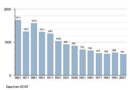
| • Total | 654 |
| • Density | 76/km2 (200/sq mi) |
| Demonym | Lenesi |
| Time zone | CET (UTC+1) |
| • Summer (DST) | CEST (UTC+2) |
| Postal code | 98050 |
| Dialing code | 090 |
| Website | Official website |
Leni is a comune (municipality) and one of the main towns on Salina, one of the Aeolian Islands. It is situated in the Province of Messina in the Italian region Sicily, located about 140 kilometres (87 mi) northeast of Palermo and about 70 kilometres (43 mi) northwest of Messina. As of 31 December 2004, it had a population of 654 and an area of 8.6 square kilometres (3.3 sq mi).[1]
Leni lies on the slope of the hill on the south of the island, 200 metres (660 ft) above the sea, between the volcanoes of Monte Fossa and Monte dei Porri.
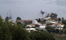
The municipality of Leni contains the frazioni (subdivisions, mainly villages and hamlets) Rinella, at the coast to the south, and Valdichiesa, in the centre of the island, to the north of Leni.
Leni borders the following municipalities: Malfa, Santa Marina Salina.
Demographic evolution
References
| Wikimedia Commons has media related to Leni. |
| Wikimedia Commons has media related to Rinella. |
| Wikimedia Commons has media related to Santuario della Madonna del Terzito (Salina). |