Lempa River
| Lempa River | |
| River | |
 Sunset over the Lempa river | |
| Countries | El Salvador, Honduras, Guatemala |
|---|---|
| Source | Sierra Madre |
| - location | Olopa, Chiquimula, Guatemala |
| - elevation | 1,200 m (3,937 ft) |
| - coordinates | 14°41′33″N 89°18′18″W / 14.69250°N 89.30500°W |
| Mouth | Pacific Ocean |
| - location | El Playón, Tecoluca, San Vicente, El Salvador |
| - elevation | 0 m (0 ft) |
| - coordinates | 13°15′17″N 88°49′38″W / 13.25472°N 88.82722°WCoordinates: 13°15′17″N 88°49′38″W / 13.25472°N 88.82722°W |
| Length | 422 km (262 mi) |
| Basin | 18,246 km2 (7,045 sq mi) |
| Discharge | for Cuscatlan bridge[1] |
| - average | 362 m3/s (12,784 cu ft/s) |
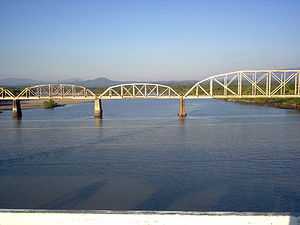 Railroad Bridge (FENADESAL) over the Lempa river, as seen from the Carretera del Litoral highway bridge (El Salvador)
| |
The Lempa River (Spanish: Río Lempa) is a 422 km long river in Central America.[2] Its sources are located in between the Sierra Madre and the Sierra del Merendón in southern Guatemala, near the town of Olopa.[2] In Guatemala the river is called Río Olopa and flows southwards for 30.4 km before entering Honduras and changing its name to Lempa river at 14°32′52″N 89°15′50″W / 14.547700°N 89.264002°W. In Honduras it flows through Ocotepeque Department for 31.4 km, and crosses the border with El Salvador at the town of Citalá (14°22′19″N 89°12′45″W / 14.371857°N 89.212439°W) in the department of Chalatenango. The river continues its course for another 360 km in El Salvador, flowing in a generally southwards direction until it reaches the Pacific Ocean in the department of San Vicente.[2][3] The river forms a small part of the international boundary between El Salvador and Honduras.
The river's watershed has an extension 18,246 km², of which 10,255 km2 (56%) is situated in El Salvador, 5,696 km2 in Honduras and 2,295 km2 in Guatemala.[1] 49% of El Salvador's territory is covered by the Lempa river basin,[1] and 77.5% of the Salvadoran population lives in cities, towns, and villages that are located in its basin, including the capital city of San Salvador.[3]
Hydroelectricity
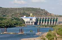
There are several hydroelectric dams along the river. In El Salvador there is the Guayojo dam, the Cerrón Grande Hydroelectric Dam, the 5 de Noviembre dam, and the 15 de Septiembre dam which can be easily seen from the Pan-American highway.
References
- ↑ 1.0 1.1 1.2 "Water Resources Assessment of El Salvador" (pdf). United States Army Corps of Engineers (USACE). 1998. Retrieved 2009-05-04.
- ↑ 2.0 2.1 2.2 Hernández, Walter (2005). "Nacimiento y Desarrollo del río Lempa" (pdf). San Salvador: Servicio Nacional de Estudios Territoriales (SNET). Retrieved 2009-05-03.
- ↑ 3.0 3.1 "Mapas de Recursos Hídricos". San Salvador: Servicio Nacional de Estudios Territoriales (SNET). Retrieved 2009-05-03.
| ||||||||||||