Leinster
| Leinster Laighin[1] | ||
|---|---|---|
| ||
 | ||
| State |
| |
| Counties |
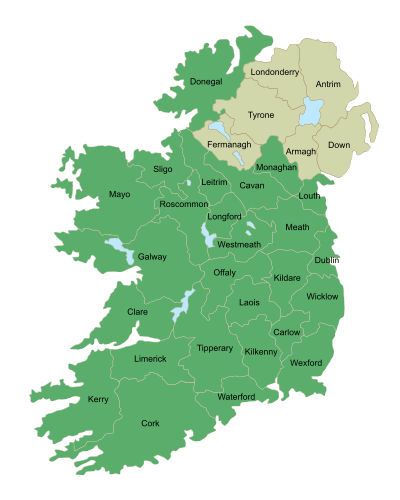
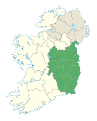
Carlow Dublin Kildare Kilkenny Laois Longford Louth Meath Offaly Westmeath Wexford Wicklow | |
| Government | ||
| • Teachta Dála |
36 Fine Gael TDs 27 Labour Party TDs 8 Fianna Fáil TDs 7 Sinn Féin TDs 6 Independent TDs 4 ULA TDs | |
| Area | ||
| • Total | 19,800 km2 (7,644 sq mi) | |
| Population (2011)[2] | ||
| • Total | 2,504,814 (1st) | |
| • Density | 126.5/km2 (328/sq mi) | |
| ISO 3166 code | IE-L | |
| Patron Saint: Brigid[3] | ||
Leinster (/ˈlɛnstər/ — Irish: Laighin / Cúige Laighean — pronounced [ˈl̪ˠaːjɪnʲ]) (Yola: lýenstrè) is one of the Provinces of Ireland situated in the east of Ireland. It comprises the ancient Kingdoms of Mide, Osraige and Leinster. Following the 12th-century Norman invasion of Ireland, the historic fifths of Leinster and Mide gradually merged, mainly due to the impact of the Pale, which straddled both, thereby forming the present-day province of Leinster. The ancient kingdoms were shired into a number of counties for administrative and judicial purposes. In later centuries, local government legislation has seen further sub-division of the historic counties.
Leinster has no official function for local-government purposes. However, the province is an officially recognised subdivision of Ireland. It is listed on ISO-3166-2 as one of the four provinces of Ireland and "IE-L" is attributed to Leinster as its country sub-division code.
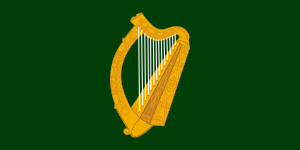
Leinster had a population of 2,504,814 according to the 2011 census, making it the most populous province in the country [4] The traditional flag of Leinster features a golden harp on a green background.
History
Early history
The Gaelic Kingdom of Leinster before 1171 was considerably smaller than today's province, and usually did not include certain territories such as Meath, Osraige or the Viking cities of Wexford and Kingdom of Dublin. The first part of the name Leinster derives from Laigin, the name of a major tribe that once inhabited the area. The latter part of the name derives either from the Irish tír or the Old Norse staðr, both of which translate as "land" or "territory".
The tribes of Leinster were united by Úgaine Mór (Hugony, the Great), who supposedly built the hill-fort of Dún Ailinne, near Kilcullen, County Kildare. He is a likely, but uncertain candidate as the first historical king of Laigin (Leinster) in the 7th century BC. The kingdom of Laigin was re-founded circa 175/185 AD following a period of civil wars in Ireland by the legendary Cathair Mor. Finn Mac Cool, or Fionn mac Cumhaill, was reputed to have built a stronghold at the Hill of Allen, on the edge of the Bog of Allen, in what was then Leinster.
In the 4th and 5th centuries, after Magnus Maximus left Britain with his legions, leaving a power vacuum, colonists from Laigin settled in North Wales, specifically in Anglesey, Carnarvonshire and Denbighshire. In Wales some of the Leinster-Irish colonists left their name on the Llŷn Peninsula, which derives its name from Laigin. In the 5th century the emerging Uí Néill dynasties from Connacht conquered areas of Westmeath, Meath and Offaly from the Uí Enechglaiss and Uí Failge of the Laigin. Uí Néill Ard Righ attempted to exact the Boroimhe Laighean, or cattle-tribute from the Laigin from that time, in the process becoming their traditional enemies.
By the 8th century, the rulers of Laigin had split into two dynasties:
- Northern Leinster dynasty: Murchad mac Brain (d. 727), King of Uí Dúnlainge, and joint leader of the Laigin
- Southern Leinster dynasty: Áed mac Colggen (d. 738), King of Uí Cheinnselaig, and joint leader of the Laigin
After the death of the last Kildare-based King of Laigin, Murchad Mac Dunlainge in 1042, the kingship of Leinster reverted to the Uí Cheinnselaig sept based in the south east, now County Wexford. This southern dynasty gave all the later Kings of Leinster.
Kingdom of Ireland period
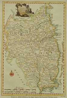
The ancient Kingdom of Mide today encompasses much of counties Meath and Westmeath with five west County Offaly baronies. The Offaly parishes of Annally and Lusmagh were formerly part of Connacht while the baronies of Ballybrit and Clonlisk were part of Éile in Munster. County Louth was formerly part of Ulster. The last major boundary changes occurred with the formation of County Wicklow (1603–1606), from lands in the north of Carlow (which previously extended to the sea) and most of southern Dublin. The provincial borders were redrawn by Cromwell for administration and military reasons. Later minor changes dealt with "islands" of one county in another. By the late 1700s, Leinster looked as shown in the above map of 1784.
Leinster represents the extended "English Pale", counties controlled directly from Dublin, at the beginning of the 1600s. The other Provinces had their own regional Presidency systems, based on a Welsh model of administration, in theory if not in fact from the 1570s and 1580s up to the 1670s, and were considered separate entities. Gradually "Leinster" subsumed the term of "The Pale", as the difference between the old Pale area and the wider province, now under English administration, grew less distinct.
Counties and Counties Corporate
Following the abolition of County Dublin, three successor counties were created that cover the same area. They are Dún Laoghaire–Rathdown,[5] Fingal and South Dublin. To these may be added the historic County Corporate of the city of Dublin, which, under the terms of the Local Government (Ireland) Act 1898 was abolished to be succeeded by the County borough of Dublin. This was in turn abolished under the terms of the Local Government Act 2001 and the area is now under the jurisdiction of Dublin City Council. The remaining counties of the province are Kildare, Offaly, Laois, Wexford, Carlow, Wicklow, Louth, Meath, Westmeath, Longford and Kilkenny. While Kilkenny city was once a county corporate, by the terms of the 1898 Act it became part of the administrative county.[6] although it retains the privilege of calling itself a city.
However, the counties of Galway, London and Antrim play in the Leinster Hurling Championship with Galway winning the title in 2012.
Irish language
There are about 40,000 Irish speakers in the province; 1,299 native speakers in the Meath Gaeltacht and this doesn't count the 19,348 attending the 66 Gaelscoils (Irish language primary schools) and 15 Gaelcholáiste (Irish language secondary schools) all across the province. According to the Irish Census 2011 there are 20,040 daily speakers outside the education system in the province.
Largest settlements (2011)
| # | Settlement | County | Population |
|---|---|---|---|
| 1 | Dublin City | County Dublin | 527,162 |
| 2 | Tallaght | County Dublin | 71,504 |
| 3 | Blanchardstown | County Dublin | 68,156 |
| 4 | Clondalkin | County Dublin | 45,165[7] |
| 5 | Drogheda | County Louth | 38,578 |
| 6 | Dundalk | County Louth | 37,816 |
| 7 | Lucan | County Dublin | 37,622 |
| 8 | Swords | County Dublin | 36,924 |
| 9 | Bray | County Wicklow | 31,872 |
| 10 | Navan | County Meath | 28,559 |
| 11 | Blackrock | County Dublin | 28,070 |
| 12 | Kilkenny | County Kilkenny | 24,423 |
| 13 | Carlow | County Carlow | 23,030 |
See also
- Kings of Leinster
- Duke of Leinster
- Leinster (European Parliament constituency)
- Leinster House
- Leinster GAA
- Leinster Rugby
- Leinster Cricket Union
- New Leinster
Notes
- ↑ ISO 3166-2 Newsletter II-1, 19 February 2010, which gives "Leinster" as the official English name of the Province and "Laighin" as the official Irish name of the Province and cites "Ordnance Survey Office, Dublin 1993" as its source - http://www.iso.org/iso/iso_3166-2_newsletter_ii-1_corrected_2010-02-19.pdf
- ↑ "Province Leinster". Central Statistics Office. 2011.
- ↑ Koch, John. Celtic Culture: A Historical Encyclopedia, Vol. 1. "Brigit (Goddess)". ABC-CLIO, 2006.
- ↑ "Province Leinster". Central Statistics Office. 2011.
- ↑ http://www.dlrcoco.ie/
- ↑ A Handbook of Local Government in Ireland (1899) p.51
- ↑ http://www.cso.ie/en/media/csoie/census/documents/census2011vol1andprofile1/Census%202011%20-%20Population%20Classified%20by%20Area.pdf
References
- Foster, R. F. The Oxford History of Ireland. Oxford University Press, Oxford & New York, 1992. ISBN 0-19-285271-X (references to Irish colony in North Wales, Lleyn Peninsula, page 6)
- Kings, Saints and Sagas, Alfred. P. Smyth, in Wicklow:History and Society, 1994. ISBN 9780906602300
- Settlement patterns in the early historic kingdom of Leinster (seventh-mid twelfth centuries), Mark Clinton, in Seanchas:Studies in Early and Medieval Irish Archaeology, History and Literature in Honour of Francis John Byrne, ed. Alfred P. Smyth, pp. 275–298, Four Courts Press, Dublin, 2000.
- Kings, the kingship of Leinster, and the regnal poems of "laidshenchas Laigen":a reflection of dynastic politics in Leinster, 650-1150, Edel Bhreathnach, Seanchas ...", pp. 299–312.
External links
- 2006 Town population estimates
- CSO Irish Regional Income/GDP 2004 Report
- Gaelscoil stats
- Irish census 2006 -
- Gaeltacht Comprehensive Language Study 2007
| ||||||||||||||||||||||||||||||