Legg's cross
Coordinates: 54°35′50″N 1°40′51″W / 54.5972°N 1.6808°W
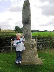
Legg's cross is an Anglo-Saxon cross in County Durham, England, about 4 miles north of Piercebridge on the Pilgrims' Way (the modern B6275 and the old Roman road of Dere Street). It is a Grade II* listed structure. [1]
The cross is now eroded to an obelisk-like structure, although it once had an inscription reading "LEG", giving rise to the name. It has been conjectured that the cross is constructed from Roman masonry (the nearby Piercebridge was once a Roman fort) and that the inscription may have originally celebrated the 20th Legion (LEGIONIS). Other theories for the name include the fact that "legge" is the Anglo-Saxon word meaning "boundary." It is also rumoured that James VI of Scotland (later I of England) rested here with his legs crossed on his way south to claim the English throne.
References
- ↑ "Name: LEGS CROSS List entry Number: 1323020". Historic England. Retrieved 12 April 2014.
| ||||||||||||||||||