Lechmere Viaduct
| Charles River Viaduct | |
|---|---|
|
The Lechmere Viaduct as viewed from East Cambridge | |
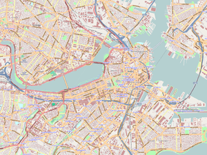
| Coordinates | 42°22′05″N 71°04′13″W / 42.36803°N 71.07035°WCoordinates: 42°22′05″N 71°04′13″W / 42.36803°N 71.07035°W |
| Carries | Light rail |
| Crosses | Charles River |
| Locale | Boston, Massachusetts to Cambridge, Massachusetts |
| Characteristics | |
| Design | Arch bridge[1] |
| Total length | 1,700 feet (520 m)[2] |
| Number of spans | 12 |
| History | |
| Construction begin | June 20, 1907[2] |
| Opened | June 1, 1912[3] |
 | |
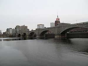
The Lechmere Viaduct is a concrete arch bridge connecting the West End of Boston to East Cambridge, Massachusetts. Opened in 1912, the viaduct carries the MBTA's Green Line over the Charles River. It is adjacent to the Charles River Dam Bridge, but structurally separate.
History
Construction
When the Tremont Street Subway fully opened in 1898, surface cars entering the subway from East Cambridge had to cross Craigie's Bridge and proceed on surface streets to the Canal Street Incline. The trip from Lechmere Point over the bridge was slow and prone to delays. On June 20, 1907, construction began on one mile of elevated track connecting the Canal Street Incline to East Cambridge. The project's centerpiece was the 1,700-foot (520 m) arched viaduct crossing the Charles River, with 12 spans including a short drawbridge section.[2] Other sections of elevated track included the Causeway Street Elevated on the Boston side of the river, and the Lechmere Elevated on the East Cambridge side. The first streetcars crossed the bridge in revenue service on June 1, 1912, shortening the ten-minute trip from Lechmere Square to the subway to just three minutes.[3][4] The building of the massive structure was done entirely by the Boston Elevated Railway, without use of subcontractors.[3]
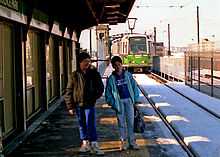
The BERy opened Lechmere station on July 10, 1922, as a transfer point between the Cambridge streetcars and the subway cars. This prevented delays affecting the surface cars from propagating into the subway, and allowed the use of three-car trains in the subway that were too long for safe street-running.[3]
Science Park station opened as an infill station on the viaduct over Leverett Circle on August 20, 1955. It serves the Boston Museum of Science and the West End.[3]
Service disruptions
On June 25, 2004, service over the viaduct was suspended as the Causeway Street Elevated was removed, and the surface and elevated platforms at North Station were consolidated into a new underground "superstation". This left the Lechmere Viaduct and Lechmere Elevated as the sole remaining elevated lines in Boston. A new portal was built off Martha Road, with a new concrete bridge connecting to the viaduct just south of Science Park station. Service to Lechmere resumed on November 12, 2005.[5]
The viaduct was again closed from April 30 to November 4, 2011, as Science Park station was rebuilt with handicapped-accessible platforms and new elevators.[5] As part of the Green Line Extension project, the northern section of the Lechmere Elevated will be removed and the elevated section of the line will be extended to a large flyover bridge crossing the Fitchburg Line tracks. The 1922 Lechmere station will be replaced with an elevated station across the street. The work may require closing the viaduct (and thus cutting service back to North Station) for 17 months, a disruption which has been opposed in Cambridge.[6]
Only the Green Line "E" Branch currently crosses the viaduct; the "B", "C", and "D" branches terminate in downtown Boston. When the Green Line Extension is complete, the "D" branch will run across the viaduct to College Avenue and the "E" Branch to Union Square. Additional service may operate to Lechmere during construction of the Extension as mitigation for delays.[7]
References
- ↑ Charles River Viaduct at Structurae
- ↑ 2.0 2.1 2.2 "STATE AND CITY OFFICIALS INSPECT NEW ELEVATED: East Cambridge Extension For Surface Cars Will Reduce Running Time From North Station to Three Minutes". Boston Globe. 28 May 1912. Retrieved 2 May 2014 – via ProQuest Historical Newspapers. (subscription required (help)).
- ↑ 3.0 3.1 3.2 3.3 3.4 Clarke, Bradley H. and Cummings, O.R. (1997). Tremont Street Subway: A Century of Public Service. Boston Street Railway Association. pp. 39–49. ISBN 0938315048.
- ↑ "VIADUCT CARS ALL RUNNING: East Cambridge Folk Much Pleased. Seven Minutes Saved and End Put to Vexatious Delays. Few Paid Fares to Say They Were on First Cars". Boston Daily Globe. 1 June 1912. Retrieved 2 May 2014 – via ProQuest Historical Newspapers. (subscription required (help)).
- ↑ 5.0 5.1 Belcher, Jonathan (22 March 2014). "Changes to Transit Service in the MBTA district" (PDF). NETransit. Retrieved 2 May 2014.
- ↑ Levy, Marc (26 February 2014). "Second 17-month T disruption looms for Lechmere; public market idea still alive". Cambridge Day. Retrieved 2 May 2014.
- ↑ Central Transportation Planning Staff (23 January 2012). "Green Line Extension SIP Mitigation Inventory" (PDF). Massachusetts Department of Transportation. Retrieved 2 May 2014.
See also
| Wikimedia Commons has media related to Lechmere Viaduct. |
| |||||||||
| ||||||||||||||||||||||||||||||||||||||||||||||||||||||||||