Leawood, Kansas
| Leawood, Kansas | |
|---|---|
| City | |
| Motto: "Growing with Distinction" | |
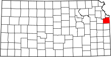
 Location within Johnson County and Kansas | |
| Coordinates: 38°55′15″N 94°37′20″W / 38.92083°N 94.62222°WCoordinates: 38°55′15″N 94°37′20″W / 38.92083°N 94.62222°W | |
| Country | United States |
| State | Kansas |
| County | Johnson |
| Established | 1948 |
| Government | |
| • Mayor | Michael McClung |
| Area[1] | |
| • Total | 15.16 sq mi (39.26 km2) |
| • Land | 15.06 sq mi (39.01 km2) |
| • Water | 0.10 sq mi (0.26 km2) |
| Elevation | 942 ft (287 m) |
| Population (2010)[2] | |
| • Total | 31,867 |
| • Estimate (2012[3]) | 32,539 |
| • Density | 2,100/sq mi (810/km2) |
| Time zone | Central (CST) (UTC-6) |
| • Summer (DST) | CDT (UTC-5) |
| ZIP | 66211 |
| Area code(s) | 913 |
| FIPS code | 20-39075 [4] |
| GNIS feature ID | 0479275 [5] |
| Website | Leawood.org |
Leawood /ˈliːwʊd/ is a city in Johnson County, Kansas, United States, and part of the Kansas City Metropolitan Area. As of the 2010 census, the city population was 31,867.[6]
History
Leawood was named for Oscar G. Lee, an original owner of the town site.[7]
Geography
Leawood is located at 38°55′15″N 94°37′20″W / 38.92083°N 94.62222°W (38.920802, -94.622118).[8] According to the United States Census Bureau, the city has a total area of 15.16 square miles (39.26 km2), of which, 15.06 square miles (39.01 km2) of it is land and 0.10 square miles (0.26 km2) is water.[1]
The City is bordered on three sides by the cities of Overland Park and Prairie Village, Kansas and on the fourth by Kansas City, Missouri. The City's land area is approximately 75% developed and growth is expected to continue in the future.[9]
Demographics
| Historical population | |||
|---|---|---|---|
| Census | Pop. | %± | |
| 1950 | 1,167 | — | |
| 1960 | 7,466 | 539.8% | |
| 1970 | 10,349 | 38.6% | |
| 1980 | 13,360 | 29.1% | |
| 1990 | 19,693 | 47.4% | |
| 2000 | 27,656 | 40.4% | |
| 2010 | 31,867 | 15.2% | |
| U.S. Decennial Census | |||
According to a 2007 estimate, the median income for a household in the city was $117,896, and the median income for a family was $136,871.[10] Males had a median income of $90,546 versus $43,933 for females. The per capita income for the city was $49,139. About 0.5% of families and 1.3% of the population were below the poverty line, including 0.5% of those under age 18 and 2.8% of those age 65 or over.
2010 census
As of the census[2] of 2010, there were 31,867 people, 11,781 households, and 9,367 families residing in the city. The population density was 2,116.0 inhabitants per square mile (817.0/km2). There were 12,384 housing units at an average density of 822.3 per square mile (317.5/km2). The racial makeup of the city was 92.3% White, 1.9% African American, 0.1% Native American, 3.8% Asian, 0.4% from other races, and 1.4% from two or more races. Hispanic or Latino of any race were 2.2% of the population.
There were 11,781 households of which 38.0% had children under the age of 18 living with them, 72.7% were married couples living together, 4.8% had a female householder with no husband present, 2.0% had a male householder with no wife present, and 20.5% were non-families. 18.1% of all households were made up of individuals and 9.6% had someone living alone who was 65 years of age or older. The average household size was 2.70 and the average family size was 3.09.
The median age in the city was 44.7 years. 28.1% of residents were under the age of 18; 4.3% were between the ages of 18 and 24; 18% were from 25 to 44; 34.3% were from 45 to 64; and 15.3% were 65 years of age or older. The gender makeup of the city was 48.5% male and 51.5% female.
2000 census
As of the census[4] of 2000, there were 27,656 people, 9,841 households, and 8,118 families residing in the city. The population density was 1,833.4 people per square mile (708.1/km²). There were 10,129 housing units at an average density of 671.5 per square mile (259.3/km²). The racial makeup of the city was 95.19% White, 1.46% African American, 0.14% Native American, 2.18% Asian, 0.01% Pacific Islander, 0.25% from other races, and 0.77% from two or more races. Hispanic or Latino of any race were 1.30% of the population.
There were 9,841 households out of which 41.4% had children under the age of 18 living with them, 76.0% were married couples living together, 5.1% had a female householder with no husband present, and 17.5% were non-families. 15.2% of all households were made up of individuals and 6.5% had someone living alone who was 65 years of age or older. The average household size was 2.81 and the average family size was 3.14.
In the city the population was spread out with 30.2% under the age of 18, 4.2% from 18 to 24, 23.2% from 25 to 44, 29.8% from 45 to 64, and 12.6% who were 65 years of age or older. The median age was 41 years. For every 100 females there were 96.1 males. For every 100 females age 18 and over, there were 93.3 males.
Religion
Leawood is home to the main campus of the United Methodist Church of the Resurrection, which is the largest church in the Kansas City Metropolitan Area and the largest Methodist church in the country with average attendance of 9,472.[11] Leawood is also home to three Catholic parishes: Church of the Nativity, Curé of Ars and St. Michael the Archangel.
Economy
Top employers
According to Leawood's 2013 Comprehensive Annual Financial Report,[12] the top employers in the city were:
| # | Employer | # of Employees |
|---|---|---|
| 1 | CBiZ | 491 |
| 2 | Reece & Nichols | 415 |
| 3 | American Academy of Family Physicians | 350 |
| 4 | Blue Valley Unified School District | 346 |
| 5 | DEMDACO | 297 |
| 6 | Select Quote | 259 |
| 7 | City of Leawood | 256 |
| 8 | Mariner | 236 |
| 9 | A.B. May | 225 |
| 10 | Euronet Worldwide | 191 |
Education
Libraries
The Johnson County Library serves the residents of Leawood.[13]
In June 2014, Leawood city officials shut down a Little Free Library due to city ordinance prohibiting free-standing structures in the front yards of residential homes[14] The family of the 9-year-old boy who built the structure created a Facebook Page to support amendment of Leawood's city code.[15] Another resident of the city who erected a Little Free Library was threatened with a $25 fine. There are discussions among the city's residents in working with the city to amend its code regarding free-standing structures in residents' front yards.[16]
Notable people
- Joe Carter, professional Major League baseball player[17]
- Trent Green, professional NFL quarterback[18]
- Jon Kempin, professional MLS soccer player
- Karen McCarthy, Missouri politician
- Joe Montana, professional NFL quarterback
- Nick Plott, StarCraft 2 eSports commentator on GOMTV[19][20]
- Sean Plott, former professional Starcraft gamer, caster, webshow host[20][21]
- Seth Sinovic, professional Major League soccer player for Sporting Kansas City
- Jack Sock, professional tennis player
- Mark Vlasic, professional NFL quarterback[22]
Sister cites
-
 Yilan City, Taiwan, Republic of China (1988)[23]
 -
 Gezer, Israel (2000)
References
- ↑ 1.0 1.1 "US Gazetteer files 2010". United States Census Bureau. Retrieved 2012-07-06.
- ↑ 2.0 2.1 "American FactFinder". United States Census Bureau. Retrieved 2012-07-06.
- ↑ "Population Estimates". United States Census Bureau. Retrieved 2013-05-29.
- ↑ 4.0 4.1 "American FactFinder". United States Census Bureau. Retrieved 2008-01-31.
- ↑ "US Board on Geographic Names". United States Geological Survey. 2007-10-25. Retrieved 2008-01-31.
- ↑ "2010 City Population and Housing Occupancy Status". U.S. Census Bureau. Retrieved March 6, 2011.
- ↑ "Leawood, Kansas". JoCoHistory. Johnson County Museum. Retrieved 12 June 2014.
- ↑ "US Gazetteer files: 2010, 2000, and 1990". United States Census Bureau. 2011-02-12. Retrieved 2011-04-23.
- ↑ City of Leawood http://www.leawood.org/aboutleawood.aspx. Retrieved 5 February 2015. Missing or empty
|title=(help) - ↑
- ↑ http://www.outreachmagazine.com/2014-outreach-100/2014-Outreach-100-List.pdf
- ↑ "City of Leawood, Kansas Comprehensive Annual Financial Report: for the Year ended December 31, 2013" (PDF). Leawood.org. Retrieved 2015-01-08.
- ↑ "JoCoLibrary". JoCoLibrary. 2011-05-02. Retrieved 2012-11-17.
- ↑ "City Forces 9-Year-Old Boy to Move "Little Free Library" From Front Yard". 20 June 2014.
- ↑ "Spencer's Little Free Library". 19 June 2014.
- ↑ "City to fine owners of Little Free Libraries". 18 June 2014.
- ↑ "Joe Carter Speaker Bio Find booking agent contact to book top speakers bureau and celebrities". Allamericanspeakers.com. 1958-08-23. Retrieved 2012-11-17.
- ↑
- ↑ Interview with Nick "Tasteless" Plott
- ↑ 20.0 20.1 Sean Plott - My Life of Starcraft - Day[9] Daily #100
- ↑ Sean Plott's Google+ page
- ↑ Mark Vlasic#Kansas City Chiefs
- ↑
Further reading
- History of the State of Kansas; William G. Cutler; A.T. Andreas Publisher; 1883. (Online HTML eBook)
- Kansas : A Cyclopedia of State History, Embracing Events, Institutions, Industries, Counties, Cities, Towns, Prominent Persons, Etc; 3 Volumes; Frank W. Blackmar; Standard Publishing Co; 944 / 955 / 824 pages; 1912. (Volume1 - Download 54MB PDF eBook),(Volume2 - Download 53MB PDF eBook), (Volume3 - Download 33MB PDF eBook)
External links
| Wikimedia Commons has media related to Leawood, Kansas. |
- City of Leawood
- Leawood - Directory of Public Officials
- Old Leawood neighborhood website
- Leawood City Map, KDOT
| |||||||||||||||||||||||||
| ||||||||||||||||||||||||

