Le Thoureil
| Le Thoureil | |
|---|---|
|
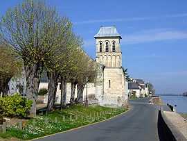
Les bords de Loire dans le village du Thoureil | |
 Le Thoureil | |
|
Location within Pays de la Loire region  Le Thoureil | |
| Coordinates: 47°22′19″N 0°15′55″W / 47.3719°N 0.2653°WCoordinates: 47°22′19″N 0°15′55″W / 47.3719°N 0.2653°W | |
| Country | France |
| Region | Pays de la Loire |
| Department | Maine-et-Loire |
| Arrondissement | Saumur |
| Canton | Gennes |
| Intercommunality |
C. C. de Gennes Pays Loire, Layon, Lys, Aubance |
| Government | |
| • Mayor (2001–2008) | Jean-Luc Lhermitte |
| Area1 | 11.02 km2 (4.25 sq mi) |
| Population (2006)2 | 410 |
| • Density | 37/km2 (96/sq mi) |
| INSEE/Postal code | 49346 / 49350 |
| Elevation |
17–84 m (56–276 ft) (avg. 35 m or 115 ft) |
|
1 French Land Register data, which excludes lakes, ponds, glaciers > 1 km² (0.386 sq mi or 247 acres) and river estuaries. 2 Population without double counting: residents of multiple communes (e.g., students and military personnel) only counted once. | |
Le Thoureil is a commune in the Maine-et-Loire department in western France.
See also
References
| Wikimedia Commons has media related to Le Thoureil. |