Le Roy Township, Coffey County, Kansas
| Le Roy Township | |
|---|---|
| Township | |
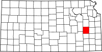
 Location in Coffey County | |
| Coordinates: 38°05′23″N 095°38′15″W / 38.08972°N 95.63750°WCoordinates: 38°05′23″N 095°38′15″W / 38.08972°N 95.63750°W | |
| Country | United States |
| State | Kansas |
| County | Coffey |
| Area | |
| • Total | 21.08 sq mi (54.59 km2) |
| • Land | 20.99 sq mi (54.38 km2) |
| • Water | 0.08 sq mi (0.21 km2) 0.38% |
| Elevation | 1,007 ft (307 m) |
| Population (2000) | |
| • Total | 669 |
| • Density | 31.9/sq mi (12.3/km2) |
| GNIS feature ID | 0478092 |
Le Roy Township is a township in Coffey County, Kansas, USA. As of the 2000 census, its population was 669.
Geography
Le Roy Township covers an area of 21.08 square miles (54.6 km2) and contains one incorporated settlement, Le Roy. According to the USGS, it contains one cemetery, Le Roy.
The streams of Crooked Creek and Duck Creek run through this township.
Transportation
Le Roy Township contains one airport or landing strip, Leroy Airport.
References
External links
| |||||||||||||||||||||