Le Grammont
| Le Grammont | |
|---|---|
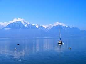 Le Grammont (left) seen from Montreux | |
| Elevation | 2,172 m (7,126 ft) |
| Prominence | 201 m (659 ft)[1] |
| Parent peak | Les Jumelles |
| Location | |
 Le Grammont Location in Switzerland | |
| Location | Valais, Switzerland |
| Range | Chablais Alps |
| Coordinates | 46°21′26.9″N 6°49′16.2″E / 46.357472°N 6.821167°ECoordinates: 46°21′26.9″N 6°49′16.2″E / 46.357472°N 6.821167°E |
| Climbing | |
| Easiest route | Trail |
Le Grammont is a mountain in the Chablais Alps, near Le Bouveret in Valais. At 2,172 metres above sea level, it is one of the highest peaks overlooking Lake Geneva. Various trails lead to the summit, mostly from the southern side.
On the way to the summit, the is a mountain lake, the Lac de Taney.
History
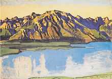
Le Grammont, by Ferdinand Hodler.
During the Second World War, there is a recorded incident of a Lancaster of the Royal Air Force getting shot down by the Swiss anti-aircraft gunners and crashing into the mountain. The pilot of the aircraft was Horace Badge and all of the crew were lost.[2]
Notes and references
- ↑ Retrieved from the Swisstopo topographic maps. The key col is the Col des Crosses (1,971 m).
- ↑ http://www.207squadron.rafinfo.org.uk/lebouveret/
See also
External links
| Wikimedia Commons has media related to Le Grammont. |