Le Donjon
| Le Donjon | ||
|---|---|---|
|
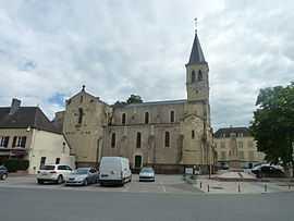
The church in Le Donjon | ||
| ||
 Le Donjon | ||
|
Location within Auvergne region  Le Donjon | ||
| Coordinates: 46°21′05″N 3°47′37″E / 46.3514°N 3.7936°ECoordinates: 46°21′05″N 3°47′37″E / 46.3514°N 3.7936°E | ||
| Country | France | |
| Region | Auvergne | |
| Department | Allier | |
| Arrondissement | Vichy | |
| Canton | Le Donjon | |
| Intercommunality | Le Donjon–Val Libre | |
| Government | ||
| • Mayor (2008–2014) | Janine Chartier | |
| Area1 | 37.02 km2 (14.29 sq mi) | |
| Population (2008)2 | 1,067 | |
| • Density | 29/km2 (75/sq mi) | |
| INSEE/Postal code | 03103 / 03130 | |
| Elevation |
265–466 m (869–1,529 ft) (avg. 292 m or 958 ft) | |
|
1 French Land Register data, which excludes lakes, ponds, glaciers > 1 km² (0.386 sq mi or 247 acres) and river estuaries. 2 Population without double counting: residents of multiple communes (e.g., students and military personnel) only counted once. | ||

Le Donjon is a commune in the Allier department in central France.
Population
| Historical population | ||
|---|---|---|
| Year | Pop. | ±% |
| 1962 | 1,502 | — |
| 1968 | 1,512 | +0.7% |
| 1975 | 1,447 | −4.3% |
| 1982 | 1,366 | −5.6% |
| 1990 | 1,258 | −7.9% |
| 1999 | 1,168 | −7.2% |
| 2008 | 1,067 | −8.6% |
See also
References
| Wikimedia Commons has media related to Le Donjon. |