Le Claux
| Le Claux | |
|---|---|
|
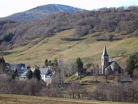
The church and surrounding buildings in Le Claux | |
 Le Claux | |
|
Location within Auvergne region  Le Claux | |
| Coordinates: 45°09′38″N 2°42′22″E / 45.1606°N 2.7061°ECoordinates: 45°09′38″N 2°42′22″E / 45.1606°N 2.7061°E | |
| Country | France |
| Region | Auvergne |
| Department | Cantal |
| Arrondissement | Saint-Flour |
| Canton | Murat |
| Intercommunality | Pays de Gentiane |
| Government | |
| • Mayor (2008–2014) | Jacques Bergeron |
| Area1 | 28.07 km2 (10.84 sq mi) |
| Population (2008)2 | 217 |
| • Density | 7.7/km2 (20/sq mi) |
| INSEE/Postal code | 15050 / 15400 |
| Elevation |
994–1,780 m (3,261–5,840 ft) (avg. 1,037 m or 3,402 ft) |
|
1 French Land Register data, which excludes lakes, ponds, glaciers > 1 km² (0.386 sq mi or 247 acres) and river estuaries. 2 Population without double counting: residents of multiple communes (e.g., students and military personnel) only counted once. | |
Le Claux is a commune in the Cantal department in south-central France.
Population
| Historical population | ||
|---|---|---|
| Year | Pop. | ±% |
| 1962 | 304 | — |
| 1968 | 405 | +33.2% |
| 1975 | 352 | −13.1% |
| 1982 | 341 | −3.1% |
| 1990 | 293 | −14.1% |
| 1999 | 260 | −11.3% |
| 2008 | 217 | −16.5% |
See also
References
| Wikimedia Commons has media related to Le Claux. |