Lavault-Sainte-Anne
| Lavault-Sainte-Anne | |
|---|---|
|
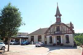
The town hall in Lavault-Sainte-Anne | |
 Lavault-Sainte-Anne | |
|
Location within Auvergne region  Lavault-Sainte-Anne | |
| Coordinates: 46°18′39″N 2°36′04″E / 46.3108°N 2.6011°ECoordinates: 46°18′39″N 2°36′04″E / 46.3108°N 2.6011°E | |
| Country | France |
| Region | Auvergne |
| Department | Allier |
| Arrondissement | Montluçon |
| Canton | Montluçon-Sud |
| Intercommunality | Montluçon |
| Government | |
| • Mayor (2008–2014) | Samir Triki |
| Area1 | 9.08 km2 (3.51 sq mi) |
| Population (2008)2 | 1,188 |
| • Density | 130/km2 (340/sq mi) |
| INSEE/Postal code | 03140 / 03100 |
| Elevation |
203–332 m (666–1,089 ft) (avg. 223 m or 732 ft) |
|
1 French Land Register data, which excludes lakes, ponds, glaciers > 1 km² (0.386 sq mi or 247 acres) and river estuaries. 2 Population without double counting: residents of multiple communes (e.g., students and military personnel) only counted once. | |
Lavault-Sainte-Anne is a commune in the Allier department in central France.
Population
| Historical population | ||
|---|---|---|
| Year | Pop. | ±% |
| 1962 | 532 | — |
| 1968 | 570 | +7.1% |
| 1975 | 1,000 | +75.4% |
| 1982 | 1,111 | +11.1% |
| 1990 | 1,131 | +1.8% |
| 1999 | 1,158 | +2.4% |
| 2008 | 1,188 | +2.6% |
See also
References
| Wikimedia Commons has media related to Lavault-Sainte-Anne. |