Last Spike (Canadian Pacific Railway)
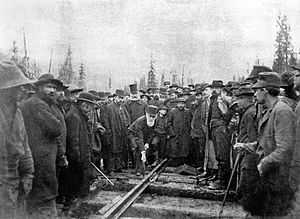
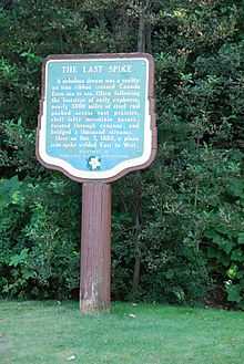
The Last Spike of the Canadian Pacific Railway was the ceremonial final spike driven into the Canadian Pacific Railway (CPR) at Craigellachie, British Columbia at 9:22 am on November 7, 1885. It was driven in by CPR railroad financier Donald Smith, marking the end of a saga of natural disasters, financial crises, and even rebellion that plagued Canada's first transcontinental railroad from its beginning.[1]

The Last Spike signalled the completion of the CPR (although the need for other work besides the track itself meant that the railway did not actually open until June 1886), driven through under engineer James Ross, it remains a symbol of national unity in Canada. At the time, it fulfilled an 1871 commitment made by the Canadian federal government to British Columbia which stipulated that a railroad be built joining the Pacific province to Central Canada. The promise of a transcontinental railway had been a major factor in British Columbia's decision to join the Canadian Confederation.[2] However, successive governments mismanaged the project and by the original deadline of 1881 little of the railway had been completed, resulting in threats of secession by some BC politicians. The work was then assigned to a newly incorporated CPR company, which was allowed an additional ten years to complete the line, and they did it in five.[3]

In contrast to the ceremonial gold or silver final spikes often used to mark the completion of other major railroads, the Last Spike was a conventional iron spike identical to the many others used in the construction of the line. A silver spike had been created for the Governor General, Henry Petty-Fitzmaurice, 5th Marquess of Lansdowne, who was to be present at the ceremony but he was forced, due to poor weather, to return with the spike to Ottawa.[4] The silver spike remained with the Van Horne family until 2012 when they donated it, along with other artifacts, to the Canadian Museum of Civilization in Gatineau, Quebec.[5] The Last Spike, the one made of iron, was removed from the track shortly after the official delegation left because it was believed that souvenir hunters might attempt to tear it up in the future. Another normal spike was inserted in its place. The actual spike was given as a gift to the son of the patent office president at the time, and is still in the family's possession, fashioned into the shape of a carving knife.[6]
The now famous photograph of Donald Alexander Smith driving in "The Last Spike" was taken by Winnipeg photographer Alexander J. Ross.[6][7]
The most notable accounts of the construction and completion of the CPR are Pierre Berton's twin volumes The National Dream and The Last Spike.Another important recollection of this event is the narrative poem entitled Towards the Last Spike by Canadian poet, E.J. Pratt.
A boardgame published under the name "The Last Spike" had as its object the financing and construction of a trans-Canadian railway.[8]
See also
| Wikimedia Commons has media related to Last Spike. |
References
- The Last Spike, by Pierre Berton
- ↑ Rudolph L. Daniels (2000). Trains Across the Continent: North American Railroad History. Indiana University Press. p. 63. ISBN 0-253-21411-4.
- ↑ Tom Murray (2011). Rails Across Canada: The History of Canadian Pacific and Canadian National Railways. MBI Publishing Company. p. 14. ISBN 978-1-61060-139-9.
- ↑ Derek Hayes (2006). Historical Atlas of Canada: Canada's History Illustrated with Original Maps. Douglas & McIntyre. p. 219. ISBN 978-1-55365-077-5.
- ↑ "The silver Spike Meant to Unite Canada". Kudos! (5). Fall 2012. Retrieved 22 December 2012.
- ↑ "A Great Canadian Legacy". The Canadian Museum of Civilization. Retrieved 26 July 2012.
- ↑ 6.0 6.1 Berton, Pierre (1971). The Last Spike. McClelland and Stewart. ISBN 0-7710-1327-2.
- ↑ "Description found in Archives: C-003693". Library and Archives Canada. Government of Canada. Retrieved 3 November 2012.
- ↑ 'The Last Spike'. Designers Tom Dalgliesh, Lance Gutteridge, Ron Gibson. Gamma Two Games, 1976.
Coordinates: 50°58′31″N 118°43′25″W / 50.97528°N 118.72361°W