Last Glacial Maximum
The Last Glacial Maximum (LGM) was a period in the Earth's climate history when ice sheets were at their most recent maximum extension, between 26,500 and 19,000–20,000 years ago,[1] marking the peak of the last glacial period. During this time, vast ice sheets covered much of North America, northern Europe and Asia. These ice sheets profoundly impacted Earth's climate, causing drought, desertification, and a dramatic drop in sea levels.[2] It was followed by the Late Glacial Maximum.
Glacial climate

The formation of an ice sheet or ice cap requires both prolonged cold and precipitation (snow). Hence, despite having temperatures similar to those of glaciated areas in North America and Europe, East Asia remained unglaciated except at higher elevations. This difference was caused by the fact that the ice sheets in Europe produced extensive anticyclones above them. These anticyclones generated air masses that were so dry on reaching Siberia and Manchuria that precipitation sufficient for the formation of glaciers could never occur (except in Kamchatka where these westerly winds lifted moisture from the Sea of Japan). The relative warmth of the Pacific Ocean due to the shutting down of the Oyashio Current and the presence of large east-west mountain ranges were secondary factors preventing continental glaciation in Asia.
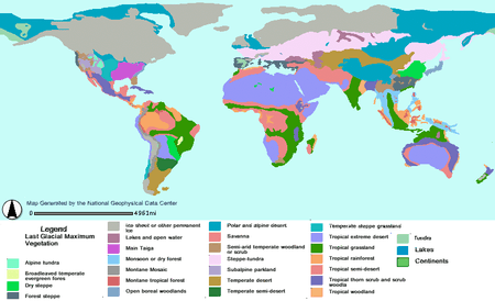
In warmer regions of the world, climates at the Last Glacial Maximum were cooler and almost everywhere drier. In extreme cases, such as South Australia and the Sahel, rainfall could be diminished by up to ninety percent from present, with floras diminished to almost the same degree as in glaciated areas of Europe and North America. Even in less affected regions, rainforest cover was greatly diminished, especially in West Africa where a few refugia were surrounded by tropical grassland. The Amazon rainforest was split into two large blocks by extensive savanna, and it is probable that the tropical rainforests of Southeast Asia were similarly affected, with deciduous forests expanding in their place except on the east and west extremities of the Sundaland shelf. Only in Central America and the Chocó region of Colombia did tropical rainforests remain substantially intact – probably due to the extraordinarily heavy rainfall of these regions.
Most of the world's deserts expanded. Exceptions were in what is now the western United States, where changes in the jet stream brought heavy rain to areas that are now desert and large pluvial lakes formed, the best known being Lake Bonneville in Utah. This also occurred in Afghanistan and Iran where a major lake formed in the Dasht-e Kavir. In Australia, shifting sand dunes covered half the continent, whilst the Chaco and Pampas in South America became similarly dry. Present-day subtropical regions also lost most of their forest cover, notably in eastern Australia, the Atlantic Forest of Brazil, and southern China, where open woodland became dominant due to drier conditions. In northern China – unglaciated despite its cold climate – a mixture of grassland and tundra prevailed, and even here, the northern limit of tree growth was at least twenty degrees farther south than today.
In the period immediately before the Last Glacial Maximum, many areas that became completely barren desert were wetter than they are today, notably in southern Australia, where Aboriginal occupation is believed to coincide with a wet period between 40,000 and 60,000 years BP (Before Present, a formal measurement of uncalibrated radiocarbon years, counted from 1950 CE).
World impact
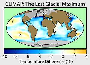
During the Last Glacial Maximum, much of the world was cold, dry, and inhospitable, with frequent storms and a dust-laden atmosphere. The dustiness of the LGM atmosphere is a prominent feature in ice cores; dust levels were as much as 20 to 25 times greater than at present.[3] This was probably due to a number of factors: reduced vegetation, stronger global winds, and less precipitation to clear dust from the atmosphere.[3] The massive sheets of ice locked away water, lowering the sea level, exposing continental shelves, joining land masses together, and creating extensive coastal plains.[4]
Europe
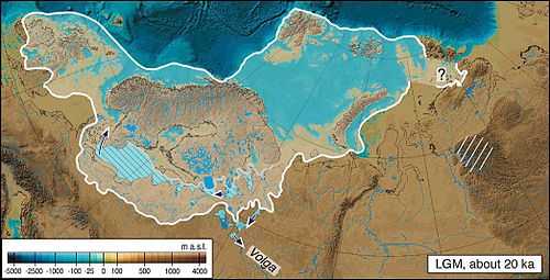
Northern Europe was largely covered by ice, the southern boundary of the ice sheets passing through Germany and Poland. This ice extended northward to cover Svalbard and Franz Josef Land and northeastward to occupy the Barents Sea, the Kara Sea and Novaya Zemlya, ending at the Taymyr Peninsula.[5]
Permafrost covered Europe south of the ice sheet down to present-day Szeged in Southern Hungary. Ice covered the whole of Iceland and almost all of the British Isles but southern England. Britain was no more than a peninsula of Europe, its north capped in ice, and its south a polar desert.
Asia
There were ice sheets in modern Tibet (although scientists continue to debate the extent to which the Tibetan Plateau was covered with ice) as well as in Baltistan and Ladakh. In Southeast Asia, many smaller mountain glaciers formed, and permafrost covered Asia as far south as Beijing. Because of lowered sea levels, many of today's islands were joined to the continents: the Indonesian islands as far east as Borneo and Bali were connected to the Asian continent in a landmass called Sundaland. Palawan was also part of Sundaland, while the rest of the Philippine Islands formed one large island separated from the continent only by the Sibutu Passage and the Mindoro Strait.[6]
Africa and the Middle East
In Africa and the Middle East, many smaller mountain glaciers formed, and the Sahara, Gobi, and other sandy deserts were greatly expanded in extent.[4]
The Persian Gulf averages about 35 metres in depth with the seabed between Abu Dhabi and Qatar even shallower, for the most part less than 15 metres deep. For thousands of years the Ur-Shatt (a confluence of the Tigris-Euphrates Rivers) provided fresh water to the Gulf, as it flowed through the Strait of Hormuz into the Gulf of Oman.
Bathymetric data suggests there were two palaeo-basins in the Persian Gulf. The central basin may have approached an area of 20,000 km², comparable at its fullest extent to lakes such as Lake Malawi in Africa. Between 12,000 and 9000 years ago much of the Gulf floor would have remained exposed, only becoming subject to marine transgression after 8,000 years ago.[7]
Australasia
Australia, New Guinea, and Tasmania were one land mass called Sahulland. Between the East Asian mass of Sundaland and Sahulland, Wallacea remained islands, though the number and width of water gaps between the two continents were considerably smaller.
North America
In North America, the ice covered essentially all of Canada and extended roughly to the Missouri and Ohio Rivers, and eastward to Manhattan. In addition to the large Cordilleran Ice Sheet in Canada and Montana, alpine glaciers advanced and (in some locations) ice caps covered much of the Rocky Mountains further south. Latitudinal gradients were so sharp that permafrost did not reach far south of the ice sheets except at high elevations. LGM glaciers forced early human populations who had originally migrated from northeast Siberia into refugia, reshaping their genetic variation through mutation and drift. This phenomenon established the older haplogroups found among Native Americans, whereas post-LGM migrations are responsible for northern North American haplogroups.[8]
On the Island of Hawaii geologists have long recognized deposits formed by glaciers on Mauna Kea during recent ice ages. The latest work indicates that deposits of three glacial episodes since 150,000 to 200,000 years ago are preserved on the volcano. Glacial moraines on the volcano formed about 70,000 years ago and from approximately 40,000 to 13,000 years ago. If glacial deposits were formed on Mauna Loa, they have long since been buried by younger lava flows.[9]
South America
In the Southern Hemisphere, the Patagonian Ice Sheet covered the whole southern third of Chile and adjacent areas of Argentina. On the western side of the Andes the ice sheet reached sea level as far north as in the 41 degrees south at Chacao Channel. The western coast of Patagonia was largely glaciated but some authors have pointed out the possible existence of ice-free refugia for some plant species. On the eastern side of the Andes glacier lobes occupied the depressions of Seno Skyring, Seno Otway, Inútil Bay and Beagle Channel. On the Straits of Magellan, ice reached as far as Segunda Angostura.[10]
See also
|
Notes
- ↑ Clark, Peter U.; Dyke, Arthur S.; Shakun, Jeremy D.; Carlson, Anders E.; Clark, Jorie; Wohlfarth, Barbara; Mitrovica, Jerry X.; Hostetler, Steven W. & McCabe, A. Marshall (2009). "The Last Glacial Maximum". Science 325 (5941): 710–4. Bibcode:2009Sci...325..710C. doi:10.1126/science.1172873. PMID 19661421.{
- ↑ Mithen, Steven (2004). After the Ice: a global human history, 20.000–5.000 BC. Cambridge MA: Harvard University Press. p. 3. ISBN 0-674-01570-3.
- ↑ 3.0 3.1 Cowen, Robert C. "Dust Plays a Huge Role in Climate Change" Christian Science Monitor 3 April 2008 (http://www.csmonitor.com/Environment/2008/0403/p14s01-sten.html), and Claquin et al., "Radiative Forcing of Climate by Ice-Age Atmospheric Dust", Climate Dynamics (2003) 20: 193–202.(www.rem.sfu.ca/COPElab/Claquinetal2003_CD_glacialdustRF.pdf)
- ↑ 4.0 4.1 Mithen 2004
- ↑ 5.0 5.1 Mangerud, Jan; Jakobsson, Martin; Alexanderson, Helena; Astakhov, Valery; Clarke, Garry K.C; Henriksen, Mona; Hjort, Christian; Krinner, Gerhard; Lunkka, Juha-Pekka; Möller, Per; Murray, Andrew; Nikolskaya, Olga; Saarnisto, Matti; Svendsen, John Inge (2004). "Ice-dammed lakes and rerouting of the drainage of northern Eurasia during the Last Glaciation" (PDF). Quaternary Science Reviews 23 (11–13): 1313–32. Bibcode:2004QSRv...23.1313M. doi:10.1016/j.quascirev.2003.12.009.
- ↑ Sathiamurthy, E.; Voris, H.K. (2006). "Pleistocene Sea Level Maps for the Sunda Shelf". Chicago IL: The Field Museum.
- ↑ http://www.qatararchaeology.com/?page_id=39#!marine-geophysics/clwj
- ↑ Perego UA, Angerhofer N, Pala M et al. (September 2010). "The initial peopling of the Americas: a growing number of founding mitochondrial genomes from Beringia". Genome Res. 20 (9): 1174–9. doi:10.1101/gr.109231.110. PMC 2928495. PMID 20587512.
- ↑ "Mauna Kea Hawai`i's Tallest Volcano". USGS.
- ↑ Rabassa, Jorge; Coronato, Andrea; Bujalesky, Gustavo; Salemme, Mónica; Roig, Claudio; Meglioli, Andrés; Heusser, Calvin; Gordillo, Sandra; Roig, Fidel; Borromei, Ana; Quattrocchio, Mirta (June 2000). "Quaternary of Tierra del Fuego, Southernmost South America: an updated review". Quaternary International. 68–71: 217–240. Bibcode:2000QuInt..68..217R. doi:10.1016/S1040-6182(00)00046-X.
Further reading
- Developments in Quaternary Science Series
- Gillespie, Alan R.; Porter, Stephen C.; Atwater, Brian F. (2003). The Quaternary Period in the United States. Elsevier. ISBN 978-0-444-51471-4.
- Ehlers, Jürgen; Gibbard, Philip L. (2004). Quaternary Glaciations Extent and Chronology. 1. Europe. Elsevier. ISBN 978-0-444-51462-2.
- Ehlers, Jürgen; Gibbard, Philip L. (2004). Quaternary Glaciations: Extent and Chronology. 2. North America. Elsevier. ISBN 978-0-444-51592-6.
- Ehlers, Jürgen; Gibbard, Philip L. (2004). Quaternary Glaciations: Extent and Chronology. 3. South America, Asia, Africa, Australia, Antarctica. Elsevier. ISBN 978-0-444-51593-3.
- Šibrava, V.; Bowen, D.Q; Richmond, G.M., ed. (1986). "Quaternary Glaciations in the Northern Hemisphere". Quaternary Science Reviews 5: 1–514. Bibcode:1986QSRv....5....1S. doi:10.1016/0277-3791(86)90167-8.
External links
- Adams, J.M. (1997). "Global land environments since the last interglacial". Atlas of Palaeovegetation: Preliminary land ecosystem maps of the world since the Last Glacial Maximum. Oak Ridge National Laboratory, TN.
- "Map and GIS database of glacial landforms and features related to the last British Ice Sheet". BRITICE. Department of Geology, University of Sheffield. 2004.
- Dyke, A.S.; Moore, A.; Robertson, L. (2003). "Deglaciation of North America". Geological Survey of Canada Open File, 1574. (32 digital maps at 1:7 000 000 scale with accompanying digital chronological database and one poster (two sheets) with full map series.)
- Manley, W.; Kuaffman, D. "Alaska PaleoGlacier Atlas: A Geospatial Compilation of Pleistocene Glacier Extents". INSTAAR. University of Colorado.
- Paleoclimate Modelling Intercomparison Project (PMIP) PMIP Web Site and 'Publications : Last Glacial Maximum.
- Paleoclimate Modelling Intercomparison Project Phase II (PMIP2) PMIP2 Home page and PMIP 2 Publications.
- Osipov, Eduard Y.; Khlystov, Oleg M. "Glaciers and meltwater flux to Lake Baikal during the Last Glacial Maximum".