Las Piñas
| Las Piñas | ||
|---|---|---|
| Highly-Urbanized City | ||
| City of Las Piñas | ||
|
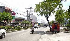
Alabang-Zapote Road, the main thoroughfare of the city | ||
| ||
| Nickname(s): Home of the Bamboo Organ, City of Love and Progress, Salt Center of Metro Manila, Lantern Capital of Metro Manila | ||
| Motto: Las Piñas, Our Home | ||
 Map of Metro Manila showing the location of Las Piñas | ||
.svg.png) Las Piñas Location within the Philippines | ||
| Coordinates: 14°27′N 120°59′E / 14.45°N 120.98°ECoordinates: 14°27′N 120°59′E / 14.45°N 120.98°E | ||
| Country | Philippines | |
| Region | National Capital Region | |
| Districts | Lone District of Las Piñas | |
| Incorporated (Town) | 1762 or 1797 | |
| Incorporated (separated from Parañaque) | March 27, 1907 | |
| Incorporated (City) | March 26, 1997 | |
| Barangays | 20 | |
| Government | ||
| • Mayor | Vergel A. Aguilar (Nacionalista) | |
| • Vice Mayor | Luis I. Bustamante (Nacionalista) | |
| • Sangguniang Panlungsod |
Councilors
| |
| Area[1] | ||
| • Total | 32.69 km2 (12.62 sq mi) | |
| Population (2010)[2] | ||
| • Total | 552,573 | |
| • Density | 17,000/km2 (44,000/sq mi) | |
| Demonym | Las Piñero | |
| Time zone | Philippine Standard Time (UTC+8) | |
| ZIP code | 1740 - 1752 | |
| Dialing code | +63 (0)02 | |
| Website |
laspinascity | |


Las Piñas, officially the City of Las Piñas (Filipino: Lungsod ng Las Piñas), is a city in the National Capital Region of the Philippines. According to the 2010 census, it has a population of 552,573.[2]
It is bounded to northeast by the Parañaque; to the southeast by Muntinlupa; to the west and southwest by Bacoor; and to the northwest by the Manila Bay. Half of its land area is residential and the remaining half is used for commercial, industrial and institutional purposes. The present physiography of Las Piñas consists of three zones: Manila Bay, coastal margin and the Guadalupe Plateau.
The city

Established as a small fishing port and becoming a major sea salt-producing municipality from several salt evaporation ponds since the Spanish Era, Las Piñas has grown into an important residential, commercial and industrial suburb of Metro Manila.
The Sarao Motors factory, also located in Las Piñas, is the place where jeepneys are assembled piece by piece in painstaking individual production. The factory remains open to buyers and curious tourists all year round.
Las Piñas also houses SM Southmall, which has an area of 205,120 square meters and is located along Alabang–Zapote Road. The newest shopping mall development in the city is SM Center Las Piñas, located few meters away from City Hall. The first high-rise building in the city is the 16-storey residential Almanza Metropolis.
Like neighbouring Muntinlupa, Las Piñas has banned the use of plastics and styrofoam in packaging.
Etymology
The story about the true origin of the city's name, "Las Piñas", varies. Some said that traders from the province of Cavite and Batangas shipped first their piña (pineapples) for sale to this town before they are distributed in nearby markets. Others related that it was "Las Peñas" (the rocks) evident by the quarrying of stones and adobe which were used to construct buildings and bridges. The old church bell of St. Joseph Parish Church founded by Fr. Diego Cera has been preserved inside the church museum. An inscription on the bell states "Siendo cura del pueblo de Laspeñas el M.R.P. Padre Diego Cera se fundio este equilon ano de 1820" showing that even during the time of Fr. Cera, the town's first parish priest, the town has been called "Las Peñas" until after sometime that the spelling of the town's name was changed into "Las Piñas".[3]
History

Las Piñas was one of the earliest fishing settlements on the shores of Manila Bay. It was proclaimed as a town of Cavite province either in 1762 or 1797. Cavada, a Spanish historian and Fr. Juan Medina placed it at 1762. Las Piñas was formerly called "Las Pilas" due to its separation from Parañaque due to tribal conflicts. On the other hand, Manuel Buzeta recorded the date at 1797. Felix Timbang was the first gobernadorcillo in year 1762 while Mariano Ortiz was the first municipal president of the town of Las Piñas. [4]
Besides being famous for its Bamboo Organ, which was built by Fr. Diego Cera and completed in 1824, the town of Las Piñas was also a major war theater during the 1896 Philippine Revolution, as it was occupied by forces of Gen. Emilio Aguinaldo. Las Piñas was occupied by the Japanese during World War II and liberated by the combined American and Filipino forces.
In 1901, the municipality of Las Piñas was separated from Cavite and incorporated to the newly created province of Rizal pursuant to the Philippine Commission Act No. 137. Two years later, it was combined with the town of Parañaque, with the latter as the seat of a new municipal government.
It was separated from Parañaque to become an independent municipality again on March 27, 1907 by virtue of Philippine Commission Act No. 1625. Then, with the founding of the Metropolitan Manila Area or Metro Manila in 1976, Las Piñas became one of the municipalities making up the region.
On February 12, 1997, President Fidel V. Ramos signed the bill which elevated Las Piñas from municipality into a city. A plebiscite held a month after approved the city status by its residents, and Las Piñas became the 10th city of Metro Manila on March 26, 1997.
Demographics
| Population census of Las Piñas | ||
|---|---|---|
| Year | Pop. | ±% p.a. |
| 1990 | 297,102 | — |
| 1995 | 413,086 | +6.37% |
| 2000 | 472,780 | +2.94% |
| 2007 | 532,330 | +1.65% |
| 2010 | 552,573 | +1.37% |
| Source: National Statistics Office[5] | ||
Local government
Las Piñas, like other cities of the Philippines, is a local government unit whose powers and functions are specified by the Local Government Code of the Philippines. In general, as a city, Las Piñas is headed by a mayor who heads the city's executive function and the vice mayor who heads the city's legislative function, which is composed of twelve councilors, six each from the city's two city council districts.[6] For representation, the city is considered as one district, and therefore one representative, in the country's House of Representatives.
Additionally, like other cities and municipalities, Las Piñas is subdivided into barangays.
Districts and barangays
Las Piñas is divided into 20 barangays. These barangays are grouped into two legislative districts, each with its own set of representatives in the city council. District 1 comprises the northwestern half of the city while District 2, the remaining half.
District 1 Barangays
|
District 2 Barangays
|
List of former mayors
Municipal Mayors:
|
City Mayors:
|
Culture


On February 22, 1995, former President Fidel V. Ramos signed Republic Act 8003 into a law - declaring Las Piñas Church and Bamboo Organ, Las Piñas Bridge, Asinan Area, Father Diego Cera Bridge, and Old District Hospital as tourist spots of Las Piñas. [7]
Las Piñas is famous for its Bamboo Organ located inside the St. Joseph Parish Church in the old district of the city. Built in 1824 by a Catholic priest, Fr. Diego Cera, it is the only organ of its kind in the world with organ pipes mostly made out of bamboo. This famous organ is praised for its unique, rare, and melodious sound.
Las Piñas Historical Corridor Project
The Las Piñas Historical Corridor Project was a program laid to restore the Old Town of Las Piñas. It was launched at the Malacañan Heroes' Hall on November 13, 1997. The project aims to educate the people of Las Piñas along the tourist corridor. [7] 18 structures were included along the historical corridor, namely;
- Boundary Arc
- Bulwagang Ezekiel Moreno
- Santuario de San Ezekiel Moreno
- Police and Fire Station
- Public Library
- Plaza Quezon - designated as the Freedom Park in the City of Las Piñas by City Ordinance No. 700-06, Series of 2006. This was in accordance with Section 15 of Batas Pambansa Blg. 880, otherwise known as the "Public Assembly Act of 1985". [8]
- Central Elementary School
- E. Aldana Police Station
- Fr. Diego Cera Bridge
- Historical and Cultural Museum
- Las Piñas Fish Port
- Irasan Center
- Las Piñas Manpower Youth Council - TESDA Building
- Zapote Police Station
- Las Piñas General Hospital and Satellite Trauma Center
- Zapote Bridge
- Brgy. Hall of Zapote
- Centennial Flyover
- Molino Dam
Las Piñas Town Feast
The town fiesta of Las Piñas is celebrated every first Sunday of May each year to honor its patron saint, Saint Joseph. Saint Joseph's Day celebration is centered in St. Joseph Parish Church in the old poblacion of Las Piñas in Brgy. Daniel Fajardo on Padre Diego Cera Ave. (Quirino Ave.). Las Piñas was also the home of Mary Immaculate Parish Church, popularly known as the Nature Church, designed by Architect Francisco "Bobby" Mañosa. [9]
Las Piñas is also home to unique festivals such as;
- International Bamboo Organ Festival, a music festival held in February celebrating the music of the unique Bamboo Organ with performances by local and foreign classical artists.[10]
- Waterlily Festival - every July 27.[11]
- "Parol" or Lantern Festival - celebrated during Christmas season.[12]
- Las Piñas City Historical Festival - celebrated every March to commemorate significant historical events that happened in the city.
List of Cultural Properties of Las Piñas
| Cultural Property wmph identifier |
Site name | Description | Province | City/Municipality | Address/Location | Coordinates | Image |
|---|---|---|---|---|---|---|---|
| De La Cruz House | The original owner was Genoveva Quilatan de la Cruz, from a political family. [13] | National Capital Region | Las Piñas | 716 San Francisco Street | 14°28′41″N 120°58′45″E / 14.478003°N 120.979163°E | 
| |
| Santos House | The house was constructed in 1932 by carpenter Pedro Arevalo. The original owners were Maximo Santos (musician) and his wife, Alita Loreto. [13] | National Capital Region | Las Piñas | 692 San Francisco Street | 14°28′45″N 120°58′48″E / 14.479031°N 120.980132°E |
| |
| Tionquiao House | The house was constructed in 1947 by carpenter Sebastian Velasquez. The original owner was Ilidian Tionquiao, a dressmaker and businesswoman. [13] | National Capital Region | Las Piñas | 680 San Francisco Street | 14°28′46″N 120°58′50″E / 14.479451°N 120.980492°E |
| |
| Cristobal House | The house was constructed in 1946. Its interiors were remodeled by Architect Dagurberto Cristobal Jr., son of the original owner, Manuel Santos Cristobal. The original owner used to work for Philippine Airlines as one of the pioneer plane technicians in the country. [13] | National Capital Region | Las Piñas | 624 San Francisco Street | 14°28′54″N 120°58′58″E / 14.481687°N 120.982643°E |
| |
| De La Cruz House | The original owners were Mercedes de la Cruz and Felisa de la Cruz, who managed an embroidery business before. [13] | National Capital Region | Las Piñas | 591 San Francisco Street | 14°28′58″N 120°59′02″E / 14.482730°N 120.983872°E |
| |
| Hernandez House | Catalina Hernandez was the mother of the original owner. [13] | National Capital Region | Las Piñas | 578 San Francisco Street | 14°28′59″N 120°59′02″E / 14.483093°N 120.983872°E |
| |
| Jose House | The house was constructed in 1942 by Ingracio Jose Sr., an oil and air brush painter and sculptor. [13] | National Capital Region | Las Piñas | 043 Padre Diego Cera Avenue (Quirino Avenue at present) | 14°28′59″N 120°59′02″E / 14.483128°N 120.983805°E |
| |
| De Leon House | The house was constructed in 1922 by Roberto de Leon. The house was turned into a local headquarters by guerrillas during the World War II. [13] | National Capital Region | Las Piñas | 810 San Jose Street | 14°28′57″N 120°58′57″E / 14.482522°N 120.982605°E |
| |
| Ortiz-Alvarez House | The house was constructed in 1930s - used to be a restaurant during the American Period. Felisa Ortiz and Marcelo Alvarez were the grandparents of the current owner. [13] | National Capital Region | Las Piñas | Padre Diego Cera Avenue (Quirino Avenue at present) | 14°28′56″N 120°58′59″E / 14.482294°N 120.983089°E |
| |
| De La Cruz House | The house was constructed in 1950s. Gloria de la Cruz, a retired piano teacher, was the current owner. [13] | National Capital Region | Las Piñas | Padre Diego Cera Avenue (Quirino Avenue at present) | 14°28′57″N 120°58′59″E / 14.482552°N 120.982997°E |
| |
| Vasquez House | The house was constructed in 1950s. At present, the house was used as a funeraria, or funeral home. [13] | National Capital Region | Las Piñas | 068 Padre Diego Cera Avenue (Quirino Avenue at present) | 14°29′00″N 120°59′01″E / 14.483446°N 120.983731°E |
| |
| Jimenez House | The house was constructed in 1930s. Perdo Jimenez, an office clerk at the Manila Post Office in Lawton, and his wife, Ezperanza Alvarez - Jimenez, an embroider, were the original owners. [13] | National Capital Region | Las Piñas | Padre Diego Cera Avenue (Quirino Avenue at present) | 14°28′56″N 120°58′58″E / 14.482244°N 120.982772°E |
| |
| Fajardo House | The house was constructed in 1939. Felang and Silvestre Fajardo, carpenter were the original owners of the house. [13] | National Capital Region | Las Piñas | 094 Padre Diego Cera Avenue (068 Quirino Avenue at present) | 14°28′56″N 120°58′58″E / 14.482153°N 120.982644°E |
| |
| Cristobal House | The house was constructed in 1919. Santiago Cristobal was the original owner of the house. [13] | National Capital Region | Las Piñas | 152 Padre Diego Cera Avenue (Quirino Avenue at present) | 14°28′49″N 120°58′50″E / 14.480206°N 120.980676°E |
| |
| Lara House | The house was constructed in 1880s. Calixto Lara, who used to own irasan, or salt beds, and his wife, Andeng Velasquez were the original owners of the house. The house became the Municipal Hall of Las Piñas from 1905-1913. [13] | National Capital Region | Las Piñas | 160 Padre Diego Cera Avenue (Quirino Avenue at present) | 14°28′46″N 120°58′48″E / 14.479344°N 120.979895°E |  | |
| Hernandez House | The house was constructed in 1927 by Luis Eusebio. He was captured by the Japanese soldiers because of his suspected affiliation with a local guerrilla. [13] | National Capital Region | Las Piñas | 253 Padre Diego Cera Avenue (Quirino Avenue at present) | 14°28′39″N 120°58′41″E / 14.477621°N 120.978123°E |
| |
| Viñalon House | Hon. Baldomero Viñalon, former Mayor of the Municipality of Muntinlupa, used to own the house. [13] | National Capital Region | Las Piñas | 912-914 Aldana Street corner Ilaya Street | 14°28′41″N 120°58′42″E / 14.478049°N 120.978251°E |
| |
| Alvarez House | The house was constructed in 1920. Lustina Aldana Alvarez was the original owner of the house. [13] | National Capital Region | Las Piñas | 934 Aldana Street | 14°28′40″N 120°58′41″E / 14.477911°N 120.978101°E |
| |
| Cristobal-Julia House | Victoria Cristobal and Monico Julia were the original owners of the house. [13] | National Capital Region | Las Piñas | 218 Aldana Street | 14°28′40″N 120°58′41″E / 14.477751°N 120.977917°E | |
Shopping Malls
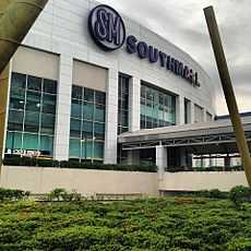
- SM Southmall is a large shopping mall owned and operated by SM Prime Holdings. The mall opened in April 1995, and is the first SM Supermall in southern region of Metro Manila, the 5th SM Supermall ever built by Chinese-Filipino businessman, Henry Sy, Sr. and the 10th largest shopping mall in the Philippines. The mall is 2nd shopping mall in the South Metro Manila Area in terms of its size which is 200,000 sq.m of land area and a total floor area of 205,120 sq.m. It went through major renovation on 2010 and currently caters to all social classes.
- Robinsons Place Las Piñas is the city's newest shopping center which opened in October 25, 2014 along Alabang-Zapote Road in Talon Tres. It is the first and only Robinsons Mall in the South Metro Manila area.
- SM Center Las Piñas is a shopping mall owned and operated by SM Prime Holdings. The mall opened on October 2, 2009, and is the second SM Supermall in Las Piñas, the 35th SM Supermall ever built by Chinese-Filipino businessman, Henry Sy, Sr.. Unlike the other SM Malls, SM Center is noted to be smaller, having no department store and only three SM-owned retail stores and is mostly visited by nearby locals for its supermarket.
- SM Hypermarket (formerly Makro; a warehouse-turned-supermarket owned by Henry Sy, Sr.)
- Starmall Las Piñas
- Starmall Las Piñas - Annex
- Puregold Las Pinas
- Evia Lifestyle Center
- Uniwide Metro Mall is a dilapidated mall which unofficially serves the lower and lower-middle classes. Originally a mall catering to the middle class with ready-to-wear clothes, due to the Asian financial crisis, Uniwide Sales, Inc. lost a lot of its net worth and became a low-maintenance shopping mall with few retail stores and a supermarket.
Transportation
Railway
Las Piñas will soon be served by the LRT-1 (via Manuyo Uno Station and Las Piñas Station).
Road network

Las Piñas is accessible through these major roads:
- Aguinaldo Highway
- Alabang–Zapote Road
- Carlos P. Garcia Avenue (C-5 Road Extension)
- Daang Hari Road (Las Piñas, Muntinlupa, Cavite, Laguna Link Road)
- Diego Cera Avenue (Quirino Avenue)
- J. Aguilar Avenue
- Manila–Cavite Expressway
- Marcos Alvarez Avenue
- Daang Reyna (Connected to Daang Hari Road)
The city is bisected by Real Street (Spanish for Royal), also known as the Alabang–Zapote Road. It forms part of the 3,517 km (2,185 mi) Maharlika Highway or Pan-Philippine Highway, a network of roads, bridges, and ferry services that connect the islands of Luzon, Samar, Leyte, and Mindanao. The Alabang–Zapote Road connects the South Luzon Expressway, which passes through Muntinlupa in the east, to Manila-Cavite Expressway (Coastal Road) along the eastern shore of Manila Bay.
Coastal Road is a major tollway which runs the southern length of Metro Manila's shoreline with Manila Bay. It is an important artery for people commuting between Las Piñas and Cavite to Manila.
In 2004, the Daang Hari (Tagalog for King's Way) motorway was completed along the Las Piñas-Muntinlupa border. The road provides an alternative access route to the inner areas of both cities, including the neighbouring towns of Bacoor, Cavite and San Pedro, Laguna. Daang Hari is also popular route for cyclists, especially on weekends.
Bus
There are several bus lines linking Las Piñas and Manila. Bus services that operates in Las Piñas includes Tas Trans Corp./Bensan Trans, Reinalyn Bus Lines, WLH Trans/WLLH Liner, MJ Sunville Transport. There are also several FX vans that goes from Manila to Las Piñas and they are usually parked in front of the Manila Central Post Office. Various jeepney routes also ply the roads between the city and neighboring cities and towns in Parañaque, Muntinlupa & Cavite .
Notable people
- Ely Buendia, songwriter, vocalist & guitarist of Eraserheads, Pupil & Oktaves
- Allan K, co-host of Eat Bulaga
- Tirso Cruz III, actor
- Jen Da Silva, model, dancer as part of the 26K girls of Kapamilya, Deal or No Deal & former housemate of Pinoy Big Brother: Celebrity Edition 2
- Mr. Fu, radio jock, comedienne and host
- Michelle Gavagan, Miss Philippines Fire 2011
- Ruben Gonzaga, comedian & winner of the Pinoy Big Brother: Celebrity Edition 2
- Jennylyn Mercado, actress & singer
- Iwa Moto, actress
- Amy Perez, actress, Host & Radio Anchor
- Raymond Bagatsing, actor
- Antonio Aquitania, actor & dancer
- Pauleen Luna, actress
- Sitti Navarro, bossa nova singer
- Queneerich Rehman, Miss World Philippines 2012, Miss World 2012, Top 15 Semifinalist
- Zara Aldana or Zephorah Aldana Mayon, Mutya ng Pilipinas 2007 Asia Pacific International & former housemate of Pinoy Big Brother: Celebrity Edition 2
- Ranidel de Ocampo, basketball player, member of Gilas Pilipinas
- Sef Cadayona, actor & dancer
- Bianca Bernardino, Writer of She's Dating the Gangster
- Jayme Jalandoni, Pinoy Big Brother All-In Housemate
- Pol Medina, Jr., author of the famous Pugad Baboy
- Enrique Gil , Artist in ABS-CBN Lives in BF Executive Las Pinas
Former Notable People
- Jam Sebastian, Student in St.Mark Institute and living in Cassimiro Village.
Sister cities
Local
 Parañaque, Metro Manila, Philippines
- Muntinlupa, Metro Manila, Philippines
- Pasay, Metro Manila, Philippines
- Bacoor, Cavite, Philippines
- Samal, Davao del Norte, Philippines
International
 Sochi, Russia
 Markham, Ontario, Canada
See also
- Battle of Zapote Bridge
- Las Piñas Boys Choir
References
- ↑ "Province: NCR, FOURTH DISTRICT". PSGC Interactive. Makati City, Philippines: National Statistical Coordination Board. Retrieved 29 November 2012.
- ↑ 2.0 2.1 "2010 Census of Population and Housing: National Capital Region" (PDF). National Statistics Office of the Republic of the Philippines. Retrieved 12 June 2012.
- ↑ Pransism (2011-11). "Las Piñas (St. Joseph Church): Home of the Bamboo Organ". Back Trails. Retrieved on 2013-04-07.
- ↑ Salonga, Isayas R. (1934). Rizal Province Directory: History, Government and General Information with the Full Text of the Philippine Independence Law, Volume One. General Printing Press.
- ↑ "Population and Annual Growth Rates for The Philippines and Its Regions, Provinces, and Highly Urbanized Cities" (PDF). 2010 Census and Housing Population. National Statistics Office. Retrieved 2012-11-07.
- ↑ Synchronized National and Local Elections Law - Republic Act No. 7166, Section 3.c.. Accessed on October 21, 2009.
- ↑ 7.0 7.1 Crisanto, Joyce & De la Torre, Visitacion (2006). Las Piñas: A City with Heritage (1st ed.). Villar Foundation.
- ↑ "City Ordinance No. 700-06, Series of 2006". The Official Website of the City of Las Piñas. Retrieved on 2014-12-20.
- ↑ "Nature Church". The Official Website of the City of Las Piñas. Retrieved on 2014-12-20.
- ↑ "Festival Program". International Bamboo Organ Festival Official Website. Retrieved on 2013-04-21.
- ↑ "Water Lily Festival". The Official Website of the City of Las Piñas. Retrieved on 2013-04-07.
- ↑ Tribune (2013-01-06). "Las Piñas City’s 7th Parol Festival". The Daily Tribune. Retrieved on 2013-04-07.
- ↑ 13.0 13.1 13.2 13.3 13.4 13.5 13.6 13.7 13.8 13.9 13.10 13.11 13.12 13.13 13.14 13.15 13.16 13.17 13.18 "The Architectural Heritage of Manila/Metro Manila Project, 1571-1961". Institute of the Philippine Culture and the Society for the Preservation of Philippine Culture, Inc. Retrieved 12 Dec 2014.
External links
| Wikimedia Commons has media related to Las Piñas City. |
- Las Piñas Chamber of Commerce & Industry
- The Las Piñas City Government's Official Site
- International Bamboo Organ Festival
 Geographic data related to Las Piñas at OpenStreetMap
 |
Manila Bay | |
Parañaque | |
| |
||||
| ||||
| | ||||
| Bacoor | |
Muntinlupa |
.jpg)