Larsen Ice Shelf
The Larsen Ice Shelf is a long, fringing ice shelf in the northwest part of the Weddell Sea, extending along the east coast of Antarctic Peninsula from Cape Longing to the area just southward of Hearst Island. Named for Captain Carl Anton Larsen, the master of the Norwegian whaling vessel Jason, who sailed along the ice front as far as 68°10' South during December 1893.[1]
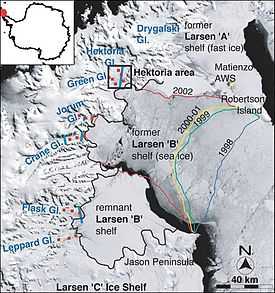
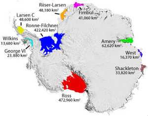
In finer detail, the Larsen Ice Shelf is a series of three shelves that occupy (or occupied) distinct embayments along the coast. From north to south, the three segments are called Larsen A (the smallest), Larsen B, and Larsen C (the largest) by researchers who work in the area. The Larsen A ice shelf disintegrated in January 1995.[2] The Larsen B ice shelf disintegrated in February 2002. The Larsen C ice shelf appeared to be stable in 2008, though scientists predict that, if localized warming continues at its current rate, the shelf could disintegrate at some point within the foreseeable future.[3]
The Larsen disintegration events were unusual by past standards. Typically, ice shelves lose mass by iceberg calving and by melting at their upper and lower surfaces. The disintegration events are linked to the ongoing climate warming in the Antarctic Peninsula, about 0.5 °C per decade since the late 1940s, which is a consequence of localized warming of the Antarctic peninsula.[4] This localized warming is caused by anthropogenic global warming, according to some scientists through strengthening of the winds circling the Antarctic.[5]
-
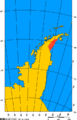
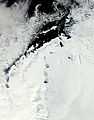
Larsen A and Larsen B iceshelves marked in red.
-
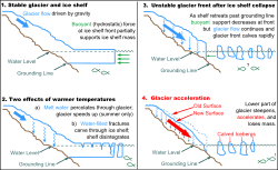
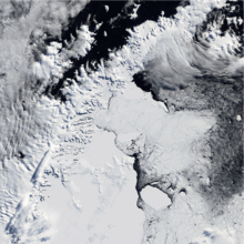
Glacier-ice shelf interactions.
-
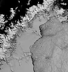
Clear view of the Antarctic Peninsula, the Larsen Ice Shelf, and the sea ice covered waters around the region.
Breakup
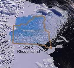
During 31 January 2002–7 March 2002 the Larsen B sector collapsed and broke up, 3,250 km² of ice 220 m thick, covering an area comparable to the US state of Rhode Island, disintegrated and collapsed in one season.[6] Larsen B was stable for up to 12,000 years, essentially the entire Holocene period since the last glacial period, according to Queen's University researchers.[7] By contrast, Larsen A "was absent for a significant part of that period and reformed beginning about 4,000 years ago," according to the study.
Despite its great age, the Larsen B was clearly in trouble at the time of the collapse. With warm currents eating away the underside of the shelf, it had become a "hotspot of global warming."[8] What especially surprised glaciologists was the speed of the breakup, which was a mere three weeks (or less). A factor they had not anticipated was the powerful effects of liquid water; ponds of meltwater formed on the surface during the near 24 hours of daylight in the summertime, then the water flowed down into cracks and, acting like a multitude of wedges, levered the shelf apart.[9][10] Global increase in air temperature was not the only factor contributing to the break according to Ted Scambos, of the University of Colorado's National Snow and Ice Data Center.
It's likely that melting from higher ocean temperatures, or even a gradual decline in the ice mass of the peninsula over the centuries, was pushing the Larsen to the brink— Ted Scambos[11]
Although the remaining Larsen C region, which is the furthest south, appears to be relatively stable for now,[12] continued warming could lead to its breakup within the next decade.[13] If disintegration should occur with this last major sector, which is greater in size than the US states of New Hampshire and Vermont combined, then the enormous Larsen Ice Shelf viewed in 1893 by Carl Anton Larsen and his crew aboard the Jason would largely be gone less than a century and a half after its discovery.
The collapse of Larsen B has revealed a thriving chemotrophic ecosystem 800 m (half a mile) below the sea. "Despite near freezing and sunless conditions, a community of clams and microbial mats are flourishing in undersea sediments. [...] The discovery was accidental. U.S. Antarctic Program scientists were in the northwestern Weddell Sea investigating the sediment record in a deep glacial trough twice the size of Texas. Methane and hydrogen sulfide associated with cold seeps is suspected as the source of the chemical energy powering the ecosystem. The area had been protected by the overlying ice sheet from debris and sediment which was seen to be building up on the white microbial mats after the breakup of the ice sheet. The clams were observed clustered about the vents.[14]
Studies show that in the middle of the present interglacial the former Larsen A region, which was the furthest north and outside the Antarctic Circle, had previously broken up and reformed only about 4,000 years ago, although the former Larsen B had been stable for at least 10,000 years.[7] The maximal ice age on the current shelf dates from only two hundred years ago. The speed of Crane Glacier increased threefold after the collapse of the Larsen B and this is likely to be due to the removal of a buttressing effect of the ice shelf.[15] Data collected in 2007 by an international team of investigators through satellite-based radar measurements suggests that the overall ice-sheet mass balance in Antarctica is increasingly negative.[16]
See also
- Glacier retreat
- List of Antarctic ice shelves
- Larsen Inlet
Notes and references
- ↑ U.S. Geological Survey Geographic Names Information System: Larsen Ice Shelf
- ↑ Scientists Trek to Collapsing Glaciers to Assess Antarctica’s Meltdown and Sea-Level Rise July 16, 2012 Scientific American
- ↑ Larsen C thinning
- ↑ Connor, Steve (2005) "Ice shelf collapse was biggest for 10,000 years since Ice Age" The Independent, London (Aug 4), online
- ↑ Marshall et al., "The Impact of a Changing Southern Hemisphere Annular Mode on Antarctic Peninsula Summer Temperatures", Journal of Climate, vol. 19, pp. 5388–5404, October 2006.
- ↑ Hulbe, Christina (2002) "Larsen Ice Shelf 2002, warmest summer on record leads to disintegration", website of Portland State University, online
- ↑ 7.0 7.1 Press Release (2005) "Ice Shelf disintegration threatens environment, Queen's study" Queens University, Kingston, Ontario, online on American Association for the Advancement of Science's Eurekalert
- ↑ Pearce, Fred (2006) The Last Generation: How Nature Will Take Her Revenge for Climate Change, Eden Project Books, p. 92
- ↑ Larsen B Ice Shelf Collapses in Antarctica
- ↑ Antarctic Ice Shelf Collapse Triggered By Warmer Summers Office of News Services, University of Colorado at Boulder, Jan. 16, 2001
- ↑ "Experts challenge ice shelf claim". Two scientists have claimed that climate change was not the only cause of the collapse of a 500bn tonne ice shelf in Antarctica six years ago. BBC News. 7 February 2008. Retrieved 2008-02-07.
- ↑ Riedl C, Rott H, Rack W (2004) "Recent Variations of Larsen Ice Shelf, Antarctic Peninsula, Observed by Envisat" Proceedings of the 2004 Envisat & ERS Symposium, Salzburg, Austria, online
- ↑ Rignot, Eric (2007) "Mass Balance and Ice Dynamics of Antarctic Peninsula Glaciers for IPY2007-2008" Proposal #359, International Polar Year Expression of Intent, online
- ↑ Domack, Eugene; Scott Ishman; Amy Leventer; Sean Sylva; Veronica Willmott; Bruce Huber (19 July 2005). "A Chemotrophic Ecosystem Found Beneath Antarctic Ice Shelf". Eos, Transactions American Geophysical Union (American Geophysical Union) 86 (29). Bibcode:2005EOSTr..86..269D. doi:10.1029/2005EO290001. Retrieved July 19, 2012.
- ↑ Rignot, E.; Casassa, G.; Gogineni, P.; Krabill, W.; Rivera, A.; Thomas, R. (2004). "Accelerated ice discharge from the Antarctic Peninsula following the collapse of Larsen B ice shelf" (PDF). Geophysical Research Letters 31 (18): L18401. Bibcode:2004GeoRL..3118401R. doi:10.1029/2004GL020697. Retrieved 2011-10-22.
- ↑ Perlman, David (2008) "Antarctic Glaciers Melting More Quickly" San Francisco Chronicle (January 26) p. A2, online
External links
| Wikinews has related news: Larson B ice-shelf collapse reveals exotic organisms isolated for 10,000 years |
| Wikimedia Commons has media related to Larsen Ice Shelf. |
- Antarctic Ice Shelves and Icebergs, U.S. National Snow and Ice Data Center
- Instituto Antártico Argentino
- Animation of Larsen B breakup, 31 January to 7 March 2002
- "Break up of the Larsen Ice Shelf, Antarctica", NASA Earth Observatory.
- Coastal-change and Glaciological Map of the Larsen Ice Shelf Area, Antarctica, 1940-2005 United States Geological Survey