Larcat
| Larcat | |
|---|---|
|
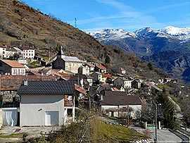
A general view of Larcat | |
 Larcat | |
|
Location within Midi-Pyrénées region  Larcat | |
| Coordinates: 42°46′47″N 1°39′44″E / 42.7797°N 1.6622°ECoordinates: 42°46′47″N 1°39′44″E / 42.7797°N 1.6622°E | |
| Country | France |
| Region | Midi-Pyrénées |
| Department | Ariège |
| Arrondissement | Foix |
| Canton | Les Cabannes |
| Intercommunality | Vallées d'Ax |
| Government | |
| • Mayor (2008–2014) | Paul Rescanieres |
| Area1 | 9.31 km2 (3.59 sq mi) |
| Population (2008)2 | 39 |
| • Density | 4.2/km2 (11/sq mi) |
| INSEE/Postal code | 09155 / 09310 |
| Elevation |
686–1,840 m (2,251–6,037 ft) (avg. 720 m or 2,360 ft) |
|
1 French Land Register data, which excludes lakes, ponds, glaciers > 1 km² (0.386 sq mi or 247 acres) and river estuaries. 2 Population without double counting: residents of multiple communes (e.g., students and military personnel) only counted once. | |
Larcat is a commune in the Ariège department in southwestern France.
Population
| Historical population | ||
|---|---|---|
| Year | Pop. | ±% |
| 1793 | 354 | — |
| 1800 | 507 | +43.2% |
| 1806 | 494 | −2.6% |
| 1821 | 32 | −93.5% |
| 1831 | 624 | +1850.0% |
| 1836 | 624 | +0.0% |
| 1841 | 589 | −5.6% |
| 1846 | 650 | +10.4% |
| 1851 | 771 | +18.6% |
| 1856 | 481 | −37.6% |
| 1861 | 568 | +18.1% |
| 1866 | 542 | −4.6% |
| 1872 | 476 | −12.2% |
| 1876 | 506 | +6.3% |
| 1881 | 518 | +2.4% |
| 1886 | 450 | −13.1% |
| 1891 | 439 | −2.4% |
| 1896 | 425 | −3.2% |
| 1901 | 417 | −1.9% |
| 1906 | 430 | +3.1% |
| 1911 | 404 | −6.0% |
| 1921 | 316 | −21.8% |
| 1926 | 270 | −14.6% |
| 1931 | 214 | −20.7% |
| 1936 | 163 | −23.8% |
| 1946 | 120 | −26.4% |
| 1954 | 101 | −15.8% |
| 1962 | 59 | −41.6% |
| 1968 | 64 | +8.5% |
| 1975 | 59 | −7.8% |
| 1982 | 51 | −13.6% |
| 1990 | 44 | −13.7% |
| 1999 | 33 | −25.0% |
| 2008 | 39 | +18.2% |
See also
References
| Wikimedia Commons has media related to Larcat. |