Laram Quta (El Alto)
| Laram Quta | |
|---|---|
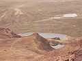
 A view of Laram Quta (the largest lake) and Phaq'u Quta (in the distance) from the top of Chacaltaya. Chacaltaya refuge is on the right. | |
| Location |
Bolivia, La Paz Department, Murillo Province |
| Coordinates | 16°22′34″S 68°7′55″W / 16.37611°S 68.13194°WCoordinates: 16°22′34″S 68°7′55″W / 16.37611°S 68.13194°W |
| Max. length | 0.5 km (0.31 mi) |
| Max. width | 0.17 km (0.11 mi) |
| Surface elevation | 4,556 m (14,948 ft) |
Laram Quta[1] (Aymara larama blue, quta lake,[2] "blue lake", hispanicized spelling Laram Kkota) is a lake in Bolivia located in the La Paz Department, Pedro Domingo Murillo Province, El Alto Municipality.[3][4] It lies south of the mountain Chacaltaya, south-east of Milluni Lake, south-west of the Qillwani Lakes and north-west of Qillwani (Khelluani). Laram Quta is situated at a height of about 4,556 metres (14,948 ft), about 0,5 km long and 0,17 km at its widest point.
Gallery
-
Laram Quta in the middle and Phaq'u Quta in the background as seen from the north
-

Laram Quta (the largest lake in the middle) as seen from Chacaltaya refuge
See also
References
- ↑ summitpost.org Map of the area showing "Laram Quta" north west of El Alto / La Paz
- ↑ Radio San Gabriel, "Instituto Radiofonico de Promoción Aymara" (IRPA) 1993, Republicado por Instituto de las Lenguas y Literaturas Andinas-Amazónicas (ILLLA-A) 2011, Transcripción del Vocabulario de la Lengua Aymara, P. Ludovico Bertonio 1612 (Spanish-Aymara-Aymara-Spanish dictionary)
- ↑ Bolivian IGM map 1:50,000 La Paz (Norte) 5944-I
- ↑ "El Alto". INE, Bolivia. Retrieved September 24, 2014. (unnamed)