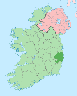
Laragh, County Wicklow
| Laragh An Láithreach | |
|---|---|
| Town | |
 Laragh Location in Ireland | |
| Coordinates: 53°00′33″N 6°17′44″W / 53.0092°N 6.2956°WCoordinates: 53°00′33″N 6°17′44″W / 53.0092°N 6.2956°W | |
| Country | Ireland |
| Province | Leinster |
| County | County Wicklow |
| Elevation | 140 m (460 ft) |
| Population (2002) | |
| • Urban | 357 |
| Time zone | WET (UTC+0) |
| • Summer (DST) | IST (WEST) (UTC-1) |
| Irish Grid Reference | T140966 |
Laragh (Irish: An Láithreach – meaning "the site, or ruins, of a building") is a small picturesque village in County Wicklow, Ireland. It lies at the junction of three roads (the R115, R755, and R756) through the Wicklow Mountains and is primarily known for its proximity to the monastic settlement of Glendalough. Sally Gap and the Glenmacnass Waterfall are to the north, to the west is Glendalough and the Wicklow Gap, and to the south is the Glenmalure Valley. The area is deeply wooded, the hills and mountains rising directly from the valley, and hill walkers, hikers, and other tourists converge on the village – given its closeness to Dublin – as their centre for recreational activities in the mountains. About 5 km from the village, on the Rathdrum road, the Clara Lara fun park covers an area of some 40 ha.
Laragh is also (especially on Sunday mornings and lunchtime) a regular meeting and stop-off point for motorcyclists and cyclists following a run over "The Gap" (the R756) before they head on to Rathdrum.
"Laragh" is the name of a fictional sheep station in Western Australia run by the Regan family in Nevil Shute's novel 'Beyond the Black Stump'.
See also
Gallery
-
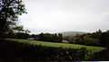
Old An Óige Youth Hostel for women north of Laragh
-
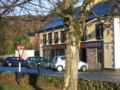
Pub in Laragh Village
External links
| ||||||||||||||||||||||