Laprugne
| Laprugne | |
|---|---|
|
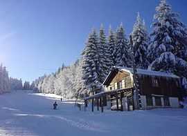
La Loge des Gardes ski resort | |
 Laprugne | |
|
Location within Auvergne region  Laprugne | |
| Coordinates: 45°59′12″N 3°44′37″E / 45.9867°N 3.7436°ECoordinates: 45°59′12″N 3°44′37″E / 45.9867°N 3.7436°E | |
| Country | France |
| Region | Auvergne |
| Department | Allier |
| Arrondissement | Vichy |
| Canton | Mayet-de-Montagne |
| Intercommunality | Montagne Bourbonnaise |
| Government | |
| • Mayor (2008–2014) | Eric Duray |
| Area1 | 34.61 km2 (13.36 sq mi) |
| Population (2008)2 | 360 |
| • Density | 10/km2 (27/sq mi) |
| INSEE/Postal code | 03139 / 03250 |
| Elevation |
549–1,164 m (1,801–3,819 ft) (avg. 700 m or 2,300 ft) |
|
1 French Land Register data, which excludes lakes, ponds, glaciers > 1 km² (0.386 sq mi or 247 acres) and river estuaries. 2 Population without double counting: residents of multiple communes (e.g., students and military personnel) only counted once. | |
Laprugne is a commune in the Allier department in central France.
Population
| Historical population | ||
|---|---|---|
| Year | Pop. | ±% |
| 1962 | 1,306 | — |
| 1968 | 1,415 | +8.3% |
| 1975 | 1,015 | −28.3% |
| 1982 | 560 | −44.8% |
| 1990 | 509 | −9.1% |
| 1999 | 410 | −19.4% |
| 2008 | 360 | −12.2% |
See also
References
| Wikimedia Commons has media related to Laprugne. |