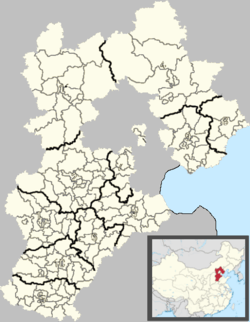
Laoting County
| Laoting County 乐亭县 | |
|---|---|
| County | |
 Laoting Location in Hebei | |
| Coordinates: 39°26′N 118°55′E / 39.433°N 118.917°ECoordinates: 39°26′N 118°55′E / 39.433°N 118.917°E | |
| Country | People's Republic of China |
| Province | Hebei |
| Prefecture-level city | Tangshan |
| Township-level divisions |
1 subdistrict 11 towns 3 townships |
| County seat | Chengqu Subdistrict (城区街道) |
| Area | |
| • Total | 1,308 km2 (505 sq mi) |
| Elevation | 12 m (38 ft) |
| Population (2003) | |
| • Total | 490,000 |
| • Density | 370/km2 (970/sq mi) |
| Time zone | China Standard (UTC+8) |
| Postal code | 063600 |
| Website |
laoting |
Laoting County (simplified Chinese: 乐亭县; traditional Chinese: 樂亭縣; pinyin: Làotíng Xiàn),[1] often pronounced as Leting County in accordance with standard Mandarin pronunciation, is a county in the northeast of Hebei province, People's Republic of China, facing the Bohai Sea to the east and south. It is under the administration of Tangshan City.
Geography and climate
Laoting has a monsoon-influenced humid continental climate (Köppen Dwa), with four distinct seasons and some maritime moderation during the summer. Winters are cold and very dry, with a January daily average temperature of −5.8 °C (21.6 °F), while summers are hot and humid, with a July daily average temperature of 24.9 °C (76.8 °F). The annual mean temperature is 10.59 °C (51.06 °F). With the monthly percent possible sunshine ranging from 45% in July to 65% in October, the area receives 2,588 hours of bright sunshine per year. A majority of the annual rainfall occurs in July and August alone.
| Climate data for Laoting County (1971−2000) | |||||||||||||
|---|---|---|---|---|---|---|---|---|---|---|---|---|---|
| Month | Jan | Feb | Mar | Apr | May | Jun | Jul | Aug | Sep | Oct | Nov | Dec | Year |
| Average high °C (°F) | 0.5 (32.9) |
3.3 (37.9) |
9.6 (49.3) |
17.9 (64.2) |
23.3 (73.9) |
27.5 (81.5) |
29.2 (84.6) |
28.9 (84) |
25.5 (77.9) |
18.6 (65.5) |
9.6 (49.3) |
2.8 (37) |
16.4 (61.5) |
| Average low °C (°F) | −10.8 (12.6) |
−8 (18) |
−1.7 (28.9) |
5.8 (42.4) |
11.6 (52.9) |
17.0 (62.6) |
21.1 (70) |
20.1 (68.2) |
14.0 (57.2) |
7.0 (44.6) |
−1 (30) |
−7.5 (18.5) |
5.6 (42.1) |
| Average precipitation mm (inches) | 3.7 (0.146) |
4.0 (0.157) |
10.1 (0.398) |
22.6 (0.89) |
47.8 (1.882) |
87.3 (3.437) |
196.7 (7.744) |
145.2 (5.717) |
47.8 (1.882) |
25.4 (1) |
11.3 (0.445) |
5.1 (0.201) |
607.0 (23.898) |
| Avg. precipitation days (≥ 0.1 mm) | 2.4 | 2.5 | 3.4 | 5.0 | 6.7 | 8.9 | 12.3 | 9.9 | 5.9 | 4.8 | 3.0 | 2.0 | 66.8 |
| Average relative humidity (%) | 57 | 57 | 59 | 58 | 63 | 73 | 82 | 83 | 74 | 69 | 65 | 60 | 66.7 |
| Mean monthly sunshine hours | 187.7 | 187.2 | 224.8 | 244.6 | 266.9 | 242.9 | 203.0 | 214.4 | 236.5 | 223.1 | 182.4 | 174.8 | 2,588.3 |
| Percent possible sunshine | 63 | 62 | 61 | 62 | 60 | 55 | 45 | 51 | 64 | 65 | 61 | 60 | 58 |
| Source: China Meteorological Administration | |||||||||||||
Administrative divisions
The county administers 1 subdistrict, 11 towns and 3 townships.[2]
Subdistricts:
- Chengqu Subdistrict (城区街道)
Towns:
- Laoting (乐亭镇), Tangjiahe (汤家河镇), Hujiatuo (胡家坨镇), Wangtan (王滩镇), Yangezhuang (闫各庄镇), Matouying (马头营镇), Xinzhai (新寨镇), Tingliuhe (汀流河镇), Jianggezhuang (姜各庄镇), Maozhuang (毛庄镇), Zhongbao (中堡镇)
Townships:
- Panggezhuang Township (庞各庄乡), Daxianggezhuang Township (大相各庄乡), Guhe Township (古河乡)
References
- ↑ 网站首页-乐亭县人民政府网 (in Chinese). Laoting County People's Government. Retrieved 2011-02-22.
- ↑ 2011年统计用区划代码和城乡划分代码:乐亭县 (in Chinese). National Bureau of Statistics of the People's Republic of China. Retrieved 2012-07-20.