Laoac, Pangasinan
| Laoac | ||
|---|---|---|
| Municipality | ||
|
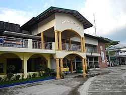
Town Hall of Laoac | ||
| ||
 Map of Pangasinan showing the location of Laoac | ||
.svg.png) Laoac Location within the Philippines | ||
| Coordinates: 16°02′N 120°33′E / 16.033°N 120.550°ECoordinates: 16°02′N 120°33′E / 16.033°N 120.550°E | ||
| Country |
| |
| Region | Ilocos (Region I) | |
| Province | Pangasinan | |
| District | 5th district of Pangasinan | |
| Founded | 1980 | |
| Barangays | 22 | |
| Government[1] | ||
| • Mayor | Silverio D. Alarcio Jr. | |
| Area[2] | ||
| • Total | 40.50 km2 (15.64 sq mi) | |
| Population (2010)[3] | ||
| • Total | 29,456 | |
| • Density | 730/km2 (1,900/sq mi) | |
| Time zone | PST (UTC+8) | |
| ZIP code | 2437 | |
| Dialing code | 75 | |
| Income class | 4th class; rural | |
| Website |
www | |

Laoac is a fourth class municipality in the province of Pangasinan, Philippines. According to the 2010 census, it has a population of 29,456 people.[3]
Barangays
Laoac is politically subdivided into 22 barangays.[2]
- Anis
- Balligi
- Banuar
- Botigue
- Caaringayan
- Domingo Alarcio (Cabilaoan East)
- Cabilaoan
- Cabulalaan
- Calaoagan
- Calmay
- Casampagaan
- Casanestebanan
- Casantiagoan
- Inmanduyan
- Poblacion (Laoac)
- Lebueg
- Maraboc
- Nanbagatan
- Panaga
- Talogtog
- Turko
- Yatyat
Demographics
| Population census of Laoac | ||
|---|---|---|
| Year | Pop. | ±% p.a. |
| 1990 | 22,864 | — |
| 1995 | 24,662 | +1.43% |
| 2000 | 26,723 | +1.74% |
| 2007 | 28,266 | +0.78% |
| 2010 | 29,456 | +1.51% |
| Source: National Statistics Office[3][4] | ||
References
- ↑ "Municipalities". Quezon City, Philippines: Department of the Interior and Local Government. Retrieved 26 November 2012.
- ↑ 2.0 2.1 "Province: PANGASINAN". PSGC Interactive. Makati City, Philippines: National Statistical Coordination Board. Retrieved 26 November 2012.
- ↑ 3.0 3.1 3.2 "Total Population by Province, City, Municipality and Barangay: as of May 1, 2010". 2010 Census of Population and Housing. National Statistics Office. Retrieved 26 November 2012.
- ↑ "Province of Pangasinan". Municipality Population Data. LWUA Research Division. Retrieved 5 September 2013.
External links
| Wikimedia Commons has media related to Laoac, Pangasinan. |
- Philippine Standard Geographic Code
- Philippine Census Information
- Local Governance Performance Management System
 |
Pozorrubio | | ||
| Manaoag | |
Binalonan | ||
| ||||
| | ||||
| Urdaneta |
| ||||||||||||||||||||||