Lantern Pike
| Lantern Pike | |
|---|---|
 | |
| Elevation | 373 m (1,224 ft) |
| Prominence | c. 88 m |
| Location | |
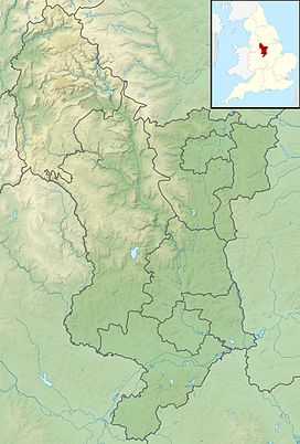 Lantern Pike Location of Lantern Pike in Derbyshire | |
| Location |
Derbyshire, |
| Range | Peak District |
| OS grid | SK026881 |
| Coordinates | 53°23′25″N 1°57′42″W / 53.39028°N 1.96167°WCoordinates: 53°23′25″N 1°57′42″W / 53.39028°N 1.96167°W |
Lantern Pike is a hill located just outside Hayfield, in Derbyshire, England. The land lies within the Peak District National Park and is owned and maintained by the National Trust. It is permanently open to the public. According to Ordnance Survey, it is 373 metres (1,224 ft) in height (measured by air survey).[1]
According to the booklet 10 Walks Around Hayfield, published by the Peak District National Park Authority, the name 'Lantern Pike' probably comes from the fact the hill was used as a beacon.
The hill is a popular hiking destination, and is often considered a continuation of nearby Kinder Scout.
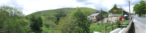
Lantern Pike gives its name to the Lantern Pike Inn, located in nearby Little Hayfield.[2]
References
- ↑ OL1 The Peak District: Dark Peak area (Map). 1:25000. Outdoor Leisure. Ordnance Survey. ISBN 978-0319240670. Retrieved 31 July 2012.
- ↑ "The Lantern Pike Inn". Retrieved 31 July 2012.