Langy
| Langy | |
|---|---|
|
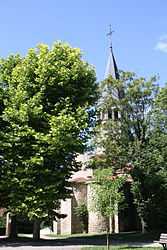
The church in Langy | |
 Langy | |
|
Location within Auvergne region  Langy | |
| Coordinates: 46°16′06″N 3°28′22″E / 46.2683°N 3.4728°ECoordinates: 46°16′06″N 3°28′22″E / 46.2683°N 3.4728°E | |
| Country | France |
| Region | Auvergne |
| Department | Allier |
| Arrondissement | Vichy |
| Canton | Varennes-sur-Allier |
| Intercommunality | Varennes Forterre |
| Government | |
| • Mayor (2008–2014) | Martine Crumiere |
| Area1 | 7.36 km2 (2.84 sq mi) |
| Population (2008)2 | 237 |
| • Density | 32/km2 (83/sq mi) |
| INSEE/Postal code | 03137 / 03150 |
| Elevation |
260–342 m (853–1,122 ft) (avg. 336 m or 1,102 ft) |
|
1 French Land Register data, which excludes lakes, ponds, glaciers > 1 km² (0.386 sq mi or 247 acres) and river estuaries. 2 Population without double counting: residents of multiple communes (e.g., students and military personnel) only counted once. | |
Langy is a commune in the Allier department in central France.
Population
| Historical population | ||
|---|---|---|
| Year | Pop. | ±% |
| 1962 | 218 | — |
| 1968 | 259 | +18.8% |
| 1975 | 227 | −12.4% |
| 1982 | 187 | −17.6% |
| 1990 | 194 | +3.7% |
| 1999 | 218 | +12.4% |
| 2008 | 237 | +8.7% |
See also
References
| Wikimedia Commons has media related to Langy. |