Langthorpe
| Langthorpe | |
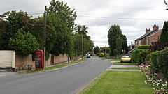 Skelton Road, Langthorpe |
|
 Langthorpe |
|
| Population | 774 |
|---|---|
| OS grid reference | SE390674 |
| Civil parish | Langthorpe |
| District | Harrogate |
| Shire county | North Yorkshire |
| Region | Yorkshire and the Humber |
| Country | England |
| Sovereign state | United Kingdom |
| Post town | YORK |
| Postcode district | YO51 9 |
| Police | North Yorkshire |
| Fire | North Yorkshire |
| Ambulance | Yorkshire |
| EU Parliament | Yorkshire and the Humber |
| UK Parliament | Skipton and Ripon (UK Parliament constituency) |
Coordinates: 54°06′04″N 1°24′15″W / 54.10122°N 1.40419°W
Langthorpe is a village and civil parish in the Harrogate district of North Yorkshire, England. It is situated to the immediate north of Boroughbridge on the A168 road.
History
The village is mentioned in the Domesday Book as Torp in the Hallikeld hundred. The lands were the possession of Gospatric, son of Arnketil both before and after the Norman invasion.[1]
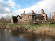
There was a brewery, Warwick's Anchor Brewery, in the village, but now disused.[2]
Governance
The village lies within the Skipton and Ripon UK Parliament constituency. It is also within the Boroughbridge electoral division of North Yorkshire County Council and the Newby ward of Harrogate Borough District Council.[3]
Geography
The nearest settlements are Boroughbridge 0.5 miles (0.80 km) to the south; Milby 0.8 miles (1.3 km) to the north-east; Kirby Hill 0.7 miles (1.1 km) to the north and Skelton-on-Ure 1.9 miles (3.1 km) to the west.[3]
The 2001 UK Census recorded the parish population as 774 of which 638 are over sixteen years old and 412 of those were in employment. There were 327 dwellings of which 122 were detached.[4]
References
- ↑ Langthorpe in the Domesday Book. Retrieved 2 January 2013.
- ↑ "Brewery". Retrieved 2 January 2013.
- ↑ 3.0 3.1 Ordnance Survey Open Viewer
- ↑ "2001 UK Census". Retrieved 1 January 2013.
External links
![]() Media related to Langthorpe at Wikimedia Commons
Media related to Langthorpe at Wikimedia Commons