Lange, Western Australia
| Lange Albany, Western Australia | |||||||||||||
|---|---|---|---|---|---|---|---|---|---|---|---|---|---|
|
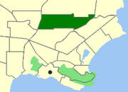
Map of Lange within Albany | |||||||||||||
| Population | 120 (2011 census)[1] | ||||||||||||
| • Density | 32.4/km2 (84/sq mi) | ||||||||||||
| Postcode(s) | 6330 | ||||||||||||
| Area | 3.7 km2 (1.4 sq mi) | ||||||||||||
| Location | 3.6 km (2 mi) from Albany | ||||||||||||
| LGA(s) | City of Albany | ||||||||||||
| State electorate(s) | Albany | ||||||||||||
| Federal Division(s) | O'Connor | ||||||||||||
| |||||||||||||
Coordinates: 34°59′38″S 117°53′13″E / 34.9938°S 117.887°E
Lange is a northern suburb of Albany in southern Western Australia, north of Albany's central business district. Its local government area is the City of Albany. The population of the suburb has a median age of 39 years.
References
- ↑ Australian Bureau of Statistics (31 October 2012). "Lange (State Suburb)". 2011 Census QuickStats. Retrieved 2015-01-04.
| ||||||
