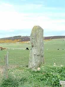
Lang Stane of Auquhollie

The Lang Stane
The Lang Stane of Auquhollie is an Ogam-inscribed standing stone some 6 kilometres north-west of Stonehaven in Scotland. Situated on south side of Meikle Carew Hill at a height of about 140 metres above sea level, the stone is approximately 3 metres in height and 0.75 metres in diameter, an unshaped monolith of gneiss.
"Discovery and context" Due to the size of the stone it is thought unlikely that it has been moved far, if it has been moved at all, from the spot at which it originally stood. 1886 Ogam noticed.
In the parish of Fetteresso: lots of stuff, Neolithic, Roman and whatever.
"Early studies" : Upload ogham PIC from CISP as it is PD-scan "Recent study" "Significance"
References and further reading
- Allen & Anderson
- Broun, Dauvit (2005), "Alba: Pictish homeland or Irish offshoot?", in O'Neill, Pamela, Exile and Homecoming. Papers from the Fifth Australian Conference of Celtic Studies, University of Sydney, July 2004, Sydney Series in Celtic Studies 8, Sydney: The Celtic Studies Foundation, University of Sydney, pp. 234–275, ISBN 1-86487-742-1
- CISP
- Diack, Francis C. (1924–1925), "The Old-Celtic Inscribed and Sculptured Stone at Auquhollie, Kincardineshire, and Ogam in Scotland.", Proceedings of the Society of Antiquaries of Scotland 59: 257–269, retrieved 2010-01-15
- Forsyth, unpub dissert
- Southesk, Earl of (1885), "The Oghams on the Brodie and Aquhollie Stones", Proceedings of the Society of Antiquaries of Scotland 20: 14–40, retrieved 2010-01-15
- Other PSAS, Henderson, xci:60
- Jürgen Uhlich. "Dov(a)- and Lenited -B- in Ogam", in Ériu 40 (1989): 129-34.
- Eoin MacNeill. "Archaisms in the Ogham Inscriptions", in Proceedings of the Royal Irish Academy. Section C: Archaeology, Celtic Studies, History, Linguistics, Literature, Vol. 39 (1929–1931): 33-53.
External links
- "Auquhollie, Lang Stane". CANMORE. Royal Commission on the Ancient and Historical Monuments of Scotland. Retrieved 2010-01-15.
- "Auquhollie". Celtic Inscribed Stones Project. Retrieved 2010-01-15.
Coordinates: 57°00′19″N 2°17′23″W / 57.00532°N 2.28974°W
| ||||||||||||||||||||||||||||||||||