Laneville, West Virginia
| Laneville | |
|---|---|
| Unincorporated community | |
 Laneville Location within the state of West Virginia | |
| Coordinates: 38°58′23″N 79°24′59″W / 38.97306°N 79.41639°WCoordinates: 38°58′23″N 79°24′59″W / 38.97306°N 79.41639°W | |
| Country | United States |
| State | West Virginia |
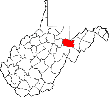
| County | Tucker |
| Time zone | Eastern (EST) (UTC-5) |
| • Summer (DST) | EDT (UTC-4) |
Laneville is an unincorporated community in Tucker County, West Virginia, USA. It lies on Red Creek (a tributary of Dry Fork of Cheat River) along the southern border of the Dolly Sods Wilderness in the Monongahela National Forest.
History
In 1902, the Parsons Pulp and Lumber Company installed a new band saw mill on Red Creek. The lumber boom town of Laneville soon sprang up around it with a population that peaked at over 300 people.[1] It was into the mill at Laneville that most of the timber of the southern two thirds of Dolly Sods disappeared. The Laneville mill closed in 1920 after almost all the timber had been cut and its population dwindled. There were fewer than 50 residents by the mid-1970s.
References
- ↑ Wilderness Committee, West Virginia Highlands Conservancy, The Dolly Sods Area — 32,000 Acres in and Adjacent to the Monongahela National Forest, West Virginia, 4th edition; Revised Sept 1973.
| |||||||||||||||||||||||||