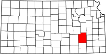
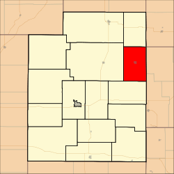
Lane Township, Greenwood County, Kansas
| Lane Township | |
|---|---|
| Township | |
 Location in Greenwood County | |
| Coordinates: 37°58′35″N 096°00′51″W / 37.97639°N 96.01417°WCoordinates: 37°58′35″N 096°00′51″W / 37.97639°N 96.01417°W | |
| Country | United States |
| State | Kansas |
| County | Greenwood |
| Area | |
| • Total | 53.63 sq mi (138.91 km2) |
| • Land | 53.35 sq mi (138.18 km2) |
| • Water | 0.28 sq mi (0.72 km2) 0.52% |
| Elevation | 981 ft (299 m) |
| Population (2000) | |
| • Total | 167 |
| • Density | 3.1/sq mi (1.2/km2) |
| GNIS feature ID | 0474450 |
Lane Township is a township in Greenwood County, Kansas, USA. As of the 2000 census, its population was 167.
Geography
Lane Township covers an area of 53.63 square miles (138.9 km2) and contains one incorporated settlement, Virgil. According to the USGS, it contains one cemetery, Virgil.
The stream of Greenhall Creek runs through this township.
References
External links
| |||||||||||||||||||||||||