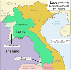
Lan Chang Province
| Lan Chang Province จังหวัดลานช้าง | ||||||
| Province of Thailand | ||||||
| ||||||
| ||||||
 | ||||||
| Historical era | World War 2 | |||||
| - | Franco-Thai War | 1941 | ||||
| - | Washington Accord of 1946 | 1946 | ||||
| Today part of | | |||||


Lan Chang Province is a former province of Thailand. It encompassed the eastern slopes of the Luang Prabang Range in Laos. Xaignabouli (Sainyabuli) was the administrative headquarters of the province. It included parts of former Luang Prabang and Xaignabouli provinces of French Laos.[1]
In 1946, after Thailand agreed to hand back the territories of French Indochina occupied in 1941 as the price for admission to the United Nations, all wartime claims against Siam were dropped and the country received a substantial package of American aid.
History
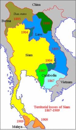
Lan Chang Province was named after the ancient Lan Xang kingdom. Its name means 'Million Elephants'. In 1904 the Laotian area of the Luang Prabang Range was ceded from Siam to colonial French Indochina.
In August 1940, just before the Franco-Thai War, Axis-aligned Thailand attacked the eastern banks of the Mekong between Vientiane and Champassak Province. Both forces would later declare war and despite French victories, the Japanese government mediated a ceasefire and compelled the French colonial government to cede Champassak Province and Xaignabouli in Laos and Battambang Province in Cambodia to Thailand in 1941. The territory was annexed by Thailand again under the name Lan Chang Province[2] The Thai administration was not very active in the province during that time and the largely rural districts were pretty much left to themselves until they were reincorporated into Laos.[3]
At the end of World War II liberated France threatened to block Thai entry into the United Nations. The government of Thailand, anxious to show its repentance for having sided with Imperial Japan through most of the war, returned the annexed provinces to their respective nations after signing the Washington Accord. Thus Lan Chang Province regained its pre-war status and rejoined Laos.[4][5]
Administrative divisions
Lan Chang Province was divided into six districts (amphoe).[6] They were established on 23 July 1941.
- Samaburi District (อำเภอสมาบุรี).
- Adundecharat District (อำเภออดุลเดชจรัส).
- Kaen Thao District (อำเภอแก่นท้าว).
- Chiang Hon District (อำเภอเชียงฮ่อน).
- Han Songkhram District (อำเภอหาญสงคราม).
- Chiang Maen District (อำเภอเชียงแมน).
See also
Bibliography
- Søren Ivarsson, Creating Laos: The Making of a Lao Space Between Indochina and Siam, 1860-1945. NIAS monographs. (May 2008) ISBN 978-8776940232
References
- ↑ Ronald Bruce St. John, The Land Boundaries of Indochina: Cambodia, Laos and Vietnam, p. 20
- ↑ Paul Lévy, Histoire du Laos, PUF, 1974, p.89-90
- ↑ ชาญวิทย์ เกษตรศิริ. ลัทธิชาตินิยมไทย/สยามกับกัมพูชาและกรณีศึกษาปราสาทพระวิหาร. กรุงเทพฯ : โครงการตำราสังคมศาสตร์ฯ.2552
- ↑ Thailand's War With Vichy France
- ↑ Cambodia – Thailand Boundary
- ↑ "ประกาสสำนักนายกรัถมนตรี เรื่องจัดตั้งอำเพอเชียงแมน จังหวัดลานช้าง". ราชกิจจานุเบกสา (in Thai) 60 (51ง): 3054. 28 กันยายน พ.ศ. 2486. Check date values in:
|date=(help)
External links
Coordinates: 19°15′N 101°30′E / 19.250°N 101.500°E
| ||||||||||||||||||||