Lamporo
| Lamporo Lampeu | |
|---|---|
| Comune | |
| Comune di Lamporo | |
 | |
 Lamporo Location of Lamporo in Italy | |
| Coordinates: 45°14′N 8°6′E / 45.233°N 8.100°ECoordinates: 45°14′N 8°6′E / 45.233°N 8.100°E | |
| Country | Italy |
| Region | Piedmont |
| Province | Province of Vercelli (VC) |
| Area | |
| • Total | 9.8 km2 (3.8 sq mi) |
| Elevation | 165 m (541 ft) |
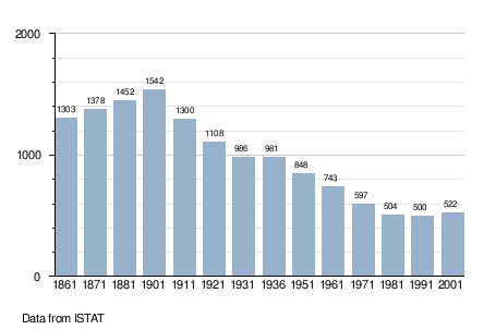
| Population (Dec. 2004) | |
| • Total | 515 |
| • Density | 53/km2 (140/sq mi) |
| Demonym | Lamporesi |
| Time zone | CET (UTC+1) |
| • Summer (DST) | CEST (UTC+2) |
| Postal code | 13040 |
| Dialing code | 0161 |
| Website | Official website |
Lamporo (Lampeu in Piedmontese) is a comune (municipality) in the Province of Vercelli in the Italian region Piedmont, located about 35 kilometres (22 mi) northeast of Turin and about 25 kilometres (16 mi) southwest of Vercelli. As of 31 December 2004, it had a population of 515 and an area of 9.8 square kilometres (3.8 sq mi).[1]
Lamporo borders the following municipalities: Crescentino, Livorno Ferraris, and Saluggia.
Demographic evolution