Lampa Province
- For other uses of Lampa see Lampa (disambiguation)
| Lampa | ||
|---|---|---|
| Province | ||
|
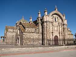
Inmaculada Concepción church in Lampa | ||
| ||
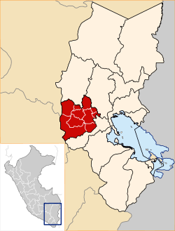 Location of Lampa in the Puno Region | ||
| Country | Peru | |
| Region | Puno | |
| Capital | Lampa | |
| Government | ||
| • Mayor |
Ciriaco Isidro Díaz Arestegui (2007-2010) | |
| Area | ||
| • Total | 5,991.73 km2 (2,313.42 sq mi) | |
| Elevation | 3,892 m (12,769 ft) | |
| Population | ||
| • Total | 48,239 | |
| • Density | 8.1/km2 (21/sq mi) | |
| UBIGEO | 2107 | |
| Website | www.munilampa.gob.pe | |
Lampa province is a province of the Puno region in Peru. Its population is about 50,000. The capital is Lampa.[1]
Political division
The province has an area of 5,791.73 square kilometers (2,236.20 sq mi) and is split into ten districts.
Geography
Some of the highest mountains of the province are:[2]
| ||
Ethnic groups
The people in the province are mainly indigenous citizens of Quechua descent. As of 2007, Quechua was the first language of 74.56% of the population; Spanish of 24.84%; and Aymara of 0.37%.[3]
See also
References
- ↑ (Spanish) Municipalidad Provincial de Lampa, Municipalidad Provincial de Lampa, Retrieved November 8, 2007.
- ↑ escale.minedu.gob.pe - UGEL map of the Lampa Province (Puno Region)
- ↑ 2007 Peru Census, inei.gob.pe INEI, Peru, Censos Nacionales 2007
External links
- (Spanish) Official website