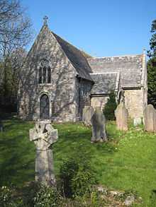
Lamorran and Merther
Lamorran and Merther is a united ecclesiastical parish in Cornwall, England, United Kingdom.
Merther is located two miles (3 km) east of Truro 50°15′54″N 5°00′05″W / 50.26488°N 5.00127°W.[1] Merther church is dedicated to St Coan[2] but is now disused and ruinous. A new church was built at Tresillian Bridge in 1904 (the font, bells, statue of St Anthony and pulpit from Merther were moved to the new church). The church was abandoned in the mid-20th century. Until 1866 Merther Church was a chapelry to Probus: it then became a separate parish but was united with Lamorran in 1900.

Lamorran is located 3 1⁄2 miles (5.6 km) southwest of Truro 50°14′30″N 4°58′29″W / 50.24165°N 4.97462°WCoordinates: 50°14′30″N 4°58′29″W / 50.24165°N 4.97462°W.[3] Lamorran lies within the Cornwall Area of Outstanding Natural Beauty (AONB). Almost a third of Cornwall has AONB designation, with the same status and protection as a National Park.
Lamorran church was built in the mid-13th century and has never been enlarged. It was dedicated (to St Morenna) in 1261 and restored unsympathetically in 1845 (by William White) and 1853 (for Lord Falmouth; Evelyn Boscawen, 6th Viscount Falmouth). The tower is separate from the church and the font of Catacleuse stone may be Norman (or 15th century work in the Norman style).[4]
A large monument of 1658 commemorates John Verman and his wife. The churchyard cross is a fine example of a Gothic stone cross.[5]

Tresawsan is a hamlet in the parish of Merther; the meaning of Tresawsan is "Englishmen's farm".[6]
Notable residents
The historian William Hals was born at Tresawsan, Merther. The naval commander Robert Carthew Reynolds was born at Lamorran: he had a long and distinguished career in the Royal Navy and died at sea on the coast of Denmark. Owen Fitzpen (also known as Owen Phippen) was an English merchant taken captive by Barbary pirates who later mounted a heroic escape; he afterwards lived at Lamorran.
References
- ↑ Ordnance Survey: Landranger map sheet 204 Truro & Falmouth ISBN 978-0-319-23149-4
- ↑ /photos/72003498%40N00/1169877846&usg=__9arVRvCv8TTsynVPWb7AghsIUu8=&h=375&w=500&sz=104&hl=en&start=5&tbnid=DPbWZ0-1KWy9WM:&tbnh=98&tbnw=130&prev=/images%3Fq%3Dalma%2Bplace%2Bredruth%26hl%3Den%26rlz%3D1T4RNWN_enGB254GB256 "Pictures of Merther Church". flickr. Retrieved 2009-04-16.
- ↑ Ordnance Survey: Landranger map sheet 204 Truro & Falmouth ISBN 978-0-319-23149-4
- ↑ Cornish Church Guide (1925) Truro: Blackford; pp. 125, 159
- ↑ Pevsner, N. (1970) Cornwall. Penguin Books; pp. 86-87
- ↑ Weatherhill, Craig (2009) A Concise Dictionary of Cornish Place-Names. Westport, Mayo: Evertype; p. 75
External links
- Merther, Cornwall; UK Genealogy Archive
| ||||||||||||||||||||||||||