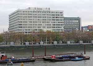
Lambeth
Coordinates: 51°29′25″N 0°07′09″W / 51.4903°N 0.1193°W
Lambeth (/ˈlæmbɪθ/) is a district in Central London, England, located in the London Borough of Lambeth. It is situated 1 mile (1.6 km) southeast of Charing Cross.
History
Toponymy
The name is recorded in 1062 as Lambehitha, meaning 'landing place for lambs', and in 1255 as Lambeth. In the Domesday Book, Lambeth is called "Lanchei", likely in error.[1] The name refers to a harbour where lambs were either shipped from or to. It is formed from the Old English 'lamb' and 'hythe'.[2] South Lambeth is recorded as Sutlamehethe in 1241 and North Lambeth is recorded in 1319 as North Lamhuth. The marshland in the area, known as Lambeth Marshe, was drained in the 18th century but is remembered in the Lower Marsh street name. Sometime after the opening of Waterloo railway station in 1848 the locality around the station and Lower Marsh became known as Waterloo.[2]
Local governance
The current district of Lambeth was part of the large ancient parish of Lambeth St Mary in the Brixton hundred of Surrey.[3] It was an elongated north-south parish with a two mile River Thames frontage to the west. In the north it lay opposite the cities of London and Westminster and extended southwards to cover the contemporary districts of Brixton, West Dulwich and West Norwood, almost reaching Crystal Palace. Lambeth became part of the Metropolitan Police District in 1829. It continued as a single parish for Poor Law purposes after the Poor Law Amendment Act 1834 and a single parish governed by a vestry after the introduction of the Metropolitan Board of Works in 1855.[3] In 1889 it became part of the county of London and the parish and vestry were reformed in 1900 to become the Metropolitan Borough of Lambeth, governed by Lambeth Borough Council. In the reform of local government in 1965 the Streatham and Clapham areas that had formed part of the Metropolitan Borough of Wandsworth were combined with Lambeth to form the London Borough of Lambeth.[3]
Urban development
Lambeth Palace is located opposite the Palace of Westminster. The two were linked by a horse ferry across the Thames.[4] Until the mid-18th Century the north of Lambeth was marshland, crossed by a number of roads raised against floods. With the opening of Westminster Bridge in 1750, followed by the Blackfriars Bridge and Vauxhall Bridge, a number of major thoroughfares were developed through Lambeth, such as Westminster Bridge Road, Kennington Road and Camberwell New Road.[4]
Literary Lambeth
In William Blake's epic Milton a Poem, the poet John Milton leaves Heaven and travels to Lambeth, in the form of a falling comet, and enters Blake's foot. This allows Blake to treat the ordinary world as perceived by the five senses as a sandal formed of "precious stones and gold" that he can now wear. Blake ties the sandal and, guided by Los, walks with it into the City of Art, inspired by the spirit of poetic creativity. The poem was written between 1804 and 1810.
Workhouse
Lambeth opened a parish workhouse in 1726. In 1777 a parliamentary report recorded a parish workhouse in operation accommodating up to 270 inmates. On 18 December 1835 the Lambeth Poor Law Parish was formed, comprising the parish of St Mary, Lambeth, "including the district attached to the new churches of St John, Waterloo, Kennington, Brixton, Norwood". Its operation was overseen by an elected Board of twenty Guardians.[5]
Transport
The nearest London Underground stations are Waterloo, Southwark and Lambeth North. London Waterloo is also a National Rail station and so is Waterloo East station which is located in-between both Waterloo and Southwark stations.
References
- ↑ Wheatley, Henry Benjamin; Cunningham, Peter (2011) [First published in 1891]. London Past and Present: Its History, Associations, and Traditions. Cambridge University Press. p. 355.
- ↑ 2.0 2.1 Mills, D. (2000). Oxford Dictionary of London Place Names. Oxford.
- ↑ 3.0 3.1 3.2 Youngs, Frederic (1979). Guide to the Local Administrative Units of England. I: Southern England. London: Royal Historical Society. ISBN 0-901050-67-9.
- ↑ 4.0 4.1 http://www.ideal-homes.org.uk/lambeth/main/index.html
- ↑ "Lambeth (Parish of St Mary), Surrey, London" at workhouses.org.uk
Further reading
- Daniel Lysons (1792), "Lambeth", Environs of London, 1: County of Surrey, London: T. Cadell
- John Timbs (1867), "Lambeth", Curiosities of London (2nd ed.), London: J.C. Hotten, OCLC 12878129
- Findlay Muirhead, ed. (1922), "Lambeth", London and its Environs (2nd ed.), London: Macmillan & Co., OCLC 365061
External links
- london-se1.co.uk local news website
- Lambeth, In Their Shoes Lambeth history resource
- Digital Public Library of America. Works related to Lambeth, various dates
| ||||||||||||||||||||||||||||||||


