Lam Thap District
| Lam Thap ลำทับ | |
|---|---|
| Amphoe | |
 Amphoe location in Krabi Province | |
| Coordinates: 8°4′18″N 99°17′30″E / 8.07167°N 99.29167°ECoordinates: 8°4′18″N 99°17′30″E / 8.07167°N 99.29167°E | |
| Country |
|
| Province | Krabi |
| Seat | Lam Thap |
| Area | |
| • Total | 320.708 km2 (123.826 sq mi) |
| Population (2005) | |
| • Total | 20,069 |
| • Density | 62.6/km2 (162/sq mi) |
| Time zone | THA (UTC+7) |
| Postal code | 81120 |
| Geocode | 8107 |
Lam Thap (Thai: ลำทับ) is a district (amphoe) of Krabi Province, southern Thailand.
History
The minor district (King Amphoe) Lam Thap was established on June 30, 1984, when the two tambon Lam Thap and Din Udom were split off from Khlong Thom district.[1] It was upgraded to a full district on November 4, 1993.[2]
Geography
Neighboring districts are (from the west clockwise) Khlong Thom and Khao Phanom of Krabi Province, Thung Yai and Bang Khan of Nakhon Si Thammarat Province, and Wang Wiset of Trang Province.
Administration
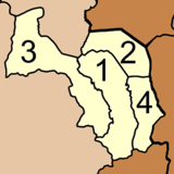
The district is subdivided into 4 subdistricts (tambon), which are further subdivided into 27 villages (muban). Lam Thap is a township (thesaban tambon) and covers parts of the tambon Lam Thap and Thung Sai Thong. There are further 4 Tambon administrative organizations (TAO).
|
 |
References
- ↑ ประกาศกระทรวงมหาดไทย เรื่อง แบ่งท้องที่อำเภอคลองท่อม จังหวัดกระบี่ ตั้งเป็นกิ่งอำเภอลำทับ. Royal Gazette (in Thai) 101 (95 ง): 2268. July 24, 1984.
- ↑ พระราชกฤษฎีกาตั้งอำเภอลำทับ อำเภอร่องคำ อำเภอเวียงแหง อำเภอนาโยง อำเภอแก้งสนามนาง อำเภอโนนแดง อำเภอบ้านหลวง อำเภอกะพ้อ อำเภอศรีบรรพต อำเภอแก่งกระจาน อำเภอหนองสูง อำเภอสบเมย อำเภอเมยวดี อำเภอโคกเจริญ อำเภอทุ่งหัวช้าง อำเภอผาขาว อำเภอวังหิน อำเภอดอนพุด อำเภอบึงโขงหลง และอำเภอห้วยคต พ.ศ. ๒๕๓๖. Royal Gazette (in Thai) 110 (179 ก special): 1–3. November 3, 1993.