Lam Brook
| Lam Brook | |
| Lambroc - Anglo-Saxon | |
| stream | |
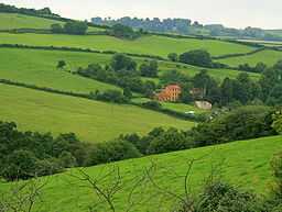
 Mill Farm on the upper reaches of the Lam Brook | |
| Country | England |
|---|---|
| Region | West of England |
| Municipality | Bath |
| Source | |
| - location | Lansdown, Bath, South Gloucestershire, England |
| - elevation | 656 ft (200 m) |
| - coordinates | 51°25′03″N 2°23′33″W / 51.4175°N 2.3926°W |
| Secondary source | |
| - location | Cold Ashton, South Gloucestershire, England |
| - elevation | 610 ft (186 m) |
| - coordinates | 51°26′45″N 2°22′12″W / 51.4458°N 2.3699°W |
| Additional source | St Johns Wood |
| - location | Toghill, South Gloucestershire, England |
| - elevation | 580 ft (177 m) |
| - coordinates | 51°26′48″N 2°23′18″W / 51.4467°N 2.3883°W |
| Mouth | Bristol Avon |
| - location | Lambridge, Bath, England |
| - elevation | 60 ft (18 m) |
| - coordinates | 51°23′44″N 2°20′21″W / 51.3955°N 2.3393°WCoordinates: 51°23′44″N 2°20′21″W / 51.3955°N 2.3393°W |
| Length | 2.5 mi (4 km), southerly |
| River system | Bristol Avon |
The Lam Brook is a stream in the West Country of England, which rises in a number of springs on the southern end of the Cotswold Hills and runs in a generally southerly direction for approximately 2.5 miles (4.0 km) before joining the river Avon at Lambridge in Bath. The brook is mentioned in an Anglo-Saxon charter of indeterminate date. There is evidence of watermills in the Swainswick valley but no working examples survive. The waters are relatively clean and support a variety of wildlife including the rare white-clawed crayfish.
Course
Streams from a number of springs issuing from the southern end of the Cotswold Hills at Lansdown, Toghill and Cold Ashton in South Gloucestershire converge at Ashcombe Farm near Langridge and the Lam Brook then runs in a generally southerly direction past Ashcombe House and the villages of Upper Swainswick and Lower Swainswick. At Lambridge the stream is joined by an unnamed tributary on the right bank just before joining the Bristol Avon.
History
It is believed that the Roman Fosse Way forded the brook near the present Lambridge.[1] Lam Brook is mentioned in an Anglo-Saxon charter as forming part of the boundaries of the village of Charlcombe. No date has yet been determined for this document.[2] In common with many other local rivers, watermills were constructed, especially in the Swainswick valley and at Lambridge. Mill Farm at Woolley survives but has been converted to other uses. A lease of 1275 refers to "two fulling mills with all appurtenances at Lambrugge ..." and a 1729 map records "Dead Mill" a little further upstream.[1]
Natural history
Salmonidae[3] and white-clawed crayfish[4] have been identified in the waters of the Lam Brook. Every year a road in Charlcombe is closed for seven weeks in February and March to allow newts, frogs and toads to safely travel down the road to reach a lake in the Charlcombe valley on an unnamed tributary of the Lam Brook.[5] [6] Toad patrol volunteer Helen Hobbs received an award from the International Fund for Animal Welfare in 2010 for her work in saving around 4,500 amphibians.[7]
References
- ↑ 1.0 1.1 Tindall, Adrian (March 2008). "Archaeological Assessment: Harvester site, Gloucester Road, Lambridge, Bath". Bath and North East Somerset Council. pp. 5–7. Retrieved 2009-12-30.
- ↑ "Charters of Bath, ed. S. E. Kelly, Anglo-Saxon Charters 13 (The British Academy, forthcoming)". The British Academy - Royal Historical Society Joint Committee on Anglo-Saxon Charters. Retrieved 2009-12-29.
- ↑ "River Basin Management Plan, South West River Basin District". Annex D. Environment Agency. December 2009. p. 67. Retrieved 2009-12-29.
- ↑ "Avon BAP Water and Wetlands Group Meeting". Avon Biodiversity Partnership. 20 May 2008. Retrieved 2009-12-29.
- ↑ Staff writer (16 January 2006). "Valentine help for lovesick toads". BBC Somerset News (BBC). Retrieved 2009-12-30.
- ↑ "Valentine help for love-struck toads". Bath & North East Somerset Council. Retrieved 2007-02-09.
- ↑ Staff (19 October 2010). "Bath toad patrol volunteer wins rescue award". BBC News. BBC. Retrieved 19 October 2010.